 |
|
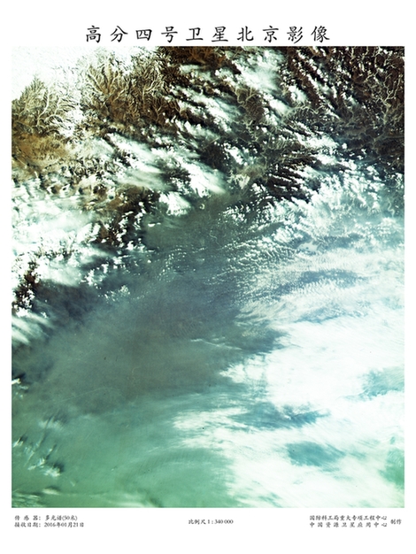
Picture taken by Gaofen-4 on Jan 21 shows smog-covered Beijing. [Photo provided to chinadaily.com.cn] |
China released the first pictures taken by its Gaofen-4 Earth observation satellite on Wednesday. They mark the first time a spacecraft has taken high-resolution images of our mother planet from an altitude of 36,000 km.
The pictures cover Beijing, the Flaming Mountains in the Xinjiang Uygur autonomous region, Namtso Lake and Qomolangma, known as Mount Everest in the West, in the Tibet autonomous region, Dunhuang in Gansu province, the Yellow River Delta and Yangtze River Delta regions, as well as some areas in Western Australia affected by forest fires in early January.
The five-metric ton Gaofen-4 was sent skyward atop a Long March 3B rocket from the Xichang Satellite Launch Center in Sichuan province on Dec 29. Seven days later, it entered geosynchronous orbit nearly 36,000 km above Earth.
By the end of January, the satellite had created about 4,600 images covering more than 26 million sq km including 8.5 million sq km in China and 17.7 million sq km overseas, according to the State Administration of Science, Technology and Industry for National Defense, which is in charge of China's space programs.
Starting from mid-March, the spacecraft will begin to take pictures for its major users such as the Ministry of Civil Affairs, State Forestry Administration, China Earthquake Administration and China Meteorological Administration to help with disaster prevention and relief, forest monitoring as well as weather forecast.
Copyright 1995 - . All rights reserved. The content (including but not limited to text, photo, multimedia information, etc) published in this site belongs to China Daily Information Co (CDIC). Without written authorization from CDIC, such content shall not be republished or used in any form. Note: Browsers with 1024*768 or higher resolution are suggested for this site.
License for publishing multimedia online 0108263 Registration Number: 130349 ![]()