Survey will cover natural features, population and highway networks
China is launching a program to provide information on real-time geographic conditions in the country as decision-makers look to get a clearer picture of how they should use the nation's resources.
|
 |
|
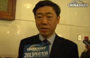
Xu Deming, director of the National Administration of Surveying, Mapping and Geoinformation |
"Policymakers will be able to get real-time information on rivers, land, forests, even the nation's output of steel with one click of a mouse, which will be crucial in drawing up future development plans," said Xu Deming, director of the National Administration of Surveying, Mapping and Geoinformation.
The program is China's first attempt to monitor its resources in real time. It is expected to be finished in December 2015, with the central government investing about 1.3 billion yuan ($210 million) in the first design phase, Xu said.
The survey will not only cover geological conditions of bodies of waters, deserts and forests, but also information such as population, regional annual output and highway networks, according to the National Administration of Surveying, Mapping and Geo-information.
"This data will help policymakers get a clearer picture of what the country has and how to make full use of it in a sustainable way," Xu said.
The program will focus on the country's issues with natural resources and assessments of changes to the nation's land surface, Xu said.
In August 2011, China released its first nationwide map to the public (on a map of scale of 1 to 500,000). The new program's scale will measure 1 to 100,000 at the very least.
But only some of the information from the new program will be released to the public on online maps of cities on government websites and Map World, the Chinese version of Google Earth. The rest will only be accessible to policymakers, he added without elaborating.
In Jiangxi province, disaster prevention and environmental protection will be emphasized in the real-time monitoring program, said Gao Zhenhua, director of the Jiangxi provincial bureau of surveying, mapping and geoinformation.
"Through the national geographic information survey, we will be clear about potential risky spots prone to natural disasters, which will help cut off economic losses and casualties," Gao said.
Gao said they will monitor real-time changes to water levels in the province's Poyang Lake, the country's largest freshwater lake, and in nearby water conservation projects, which will be crucial in future economic development plans.
"China is taking the lead in the world's surveying and mapping industry," said Wu Hongbo, under-secretary-general for the United Nations economic and social affairs.
"The national geographic information survey will play a crucial role in guaranteeing the country's sustainable development," said Wu, who added that if a local government knows how much arable land it has, it can then calculate how many people it can feed.
According to the latest statistics released by the National Administration of Surveying, Mapping and Geoinformation, annual revenue in the surveying and mapping industry in China reached 100 billion yuan as of 2012 with more than 400,000 workers.
wangqian@chinadaily.com.cn
 Buick Riviera concept car at 2013 Auto Guangzhou
 FAW-VW all-new Golf at Guangzhou auto show
 VW donates more than 5k child safety seats
 Honda models at 2013 Guangzhou auto show
 Honda Jade at the 2013 Guangzhou auto show
 Toyota's new Reiz debuts at 2013 Auto Guangzhou
 Jimmy Lin Zhiying, models at Toyota pavilion
 Volvo all-new S60L world premiere at Guangzhou auto show
Copyright 1995 - . All rights reserved. The content (including but not limited to text, photo, multimedia information, etc) published in this site belongs to China Daily Information Co (CDIC). Without written authorization from CDIC, such content shall not be republished or used in any form. Note: Browsers with 1024*768 or higher resolution are suggested for this site.
License for publishing multimedia online 0108263 Registration Number: 20100000002731 ![]()