
Ningde Global GeoPark
( chinadaily.com.cn )
Updated: 2011-04-01
Land formations
The park is located in the continental marginal active zone of the western Pacific Ocean. Baiyun Mountain Scenic Area and Taimu Mountain Scenic Area boast land formations such as peak clusters, rock castles, rock walls, rock columns and rock eggs, and also deep canyons, a valley and cave.
It is representative of granite landforms, and thus has special scientific significance and protective value as a place for the scientific research and observation of granite landform. Baiyun Mountain Scenic Area and Baishuiyang Scenic Area of the park also are home to volcanic land formations.
The formations range from hardened lava, a rock castle, rock walls and rock columns to a deep canyon and cave. also have developed deep canyon, cave and other negative landforms. They together form a variety of distinctive volcanic landform landscapes. The Liuyang volcanic basin in the middle of the park has developed a series of volcanic structures and other spectacular geological land formations.
Climate
The park is located on the southeastern coast of China and has a subtropical maritime monsoon climate. It possesses the features of multiple climates such as mountain climate and basin valley. The four seasons are clear. The temperature differences between the coast and inland can be significant, and disastrous weather can be frequently. The annual average air temperature is 18.8 C in the coastal cities and counties. The hottest month is July, with the average temperature reaching 28.6 C.
The coldest month is January, when temperatures drop to an average 8.9 C. In the mountainous inland counties, temperatures can reach an average of 24.4 C in July, and 5.2 C in January. Annual average rainfall increases gradually from the coastal areas to the mountainous areas. The annual average rainfall is above 1,600 millimeters. The annual average relative humidity is 78 percent to 83 percent. Humidity in mountainous areas is higher than in costal areas. The area can suffer gales, typhoons, rainstorms and drought .
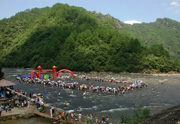
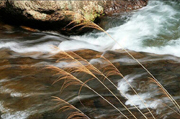
Water Resources
Baishuiyang Scenic Area features streams, ravines and gullies. Xiacun, Tantou, Yanhou, Houqiao, Yiyang, Zhengshan, Xiyan, Kaoxi and Qianyang each have one stream flowing into Yuanyang Creek. Yuanyang Creek is 18 kilometers long, with a drop of more than 300 meters. In Baiyun Mountain Scenic Area, the water system is developed, and Chanxi, Zhuzhou and Qiangping each have a stream flowing into Muyang Creek.
Muyang Creek is 116 kilometers long, with a drainage area of 1.389 square kilometers. Muyang Creek is originated from Zhenghe Town, flows by Heyang in Zhouning, and Shekou, Muyang, Kangcuo and Xitan in Fuan, and merges into the Fuchun Creek (also known as Jiaoxi Creek) in front of Lianshou Village, Saiqi in eastern Fujian. The river merging the two creeks is called Saijiang River. Jiaoxi Creek (known as Fuchun Creek in the urban area of Fuan) originates in the Jiufeng, Donggong and Taimu mountain ranges, with a drainage area of 5.638 square kilometers. Its main tributaries are 433 kilometers long in total.
It is the third largest river in Fujian. In the park, there are Huanglan Lake, Jiulong Lake, Jinchan Lake and reservoirs. The water system in Taimu Mountain Scenic Area directly flows into the sea. The larger water system is Yangjia Creek passing by the southwest of the park (also known as Jiuli Creek or Chixi Creek) and originating in Lixian County (also known as Tuorong County). It flows from west to east into the area, then turns southward and runs into the sea from Yacheng, Xiapu. The drainage area in Fuding City is 250 square kilometers. The main creek is 23.3 kilometers long.