To fend off Japanese pirates (operating in the Chinese coastal waters from the 14th century to the 16th century), China had already included the Diaoyu Islands in its sphere of defence in the early Ming Dynasty. In 1561, the 40th year of the Jiajing Reign (1522-1566), Zheng Ruoceng, a famous Chinese strategist and geographer in the Ming dynasty, under the direction of Hu Zongxian, the supreme commander in charge of southeastern coastal defence, compiled a geographic and maritime defence document called An Illustrated Compendium of Maritime Security. The first volume of the historical document explicitly recorded diaoyuyu, huangmaoshan and chiyu, namely, today’s Diaoyu Islands, Huangwei Island and Chiwei Island, under the Ming imperial jurisdiction. The historical document is sound evidence that China had already placed these islands under its defence in the Ming Dynasty at the latest. China’s maps, published in 1579 (The Roadmap to Ryukyu) 1629 (The Records of Xiangxu in Ming Dynasty),1767 (The Atlas of Kunyu) and 1863 (The Atlas of the Great Qing Dynasty) all included the Diaoyu Islands and their affiliated islands in its territory.
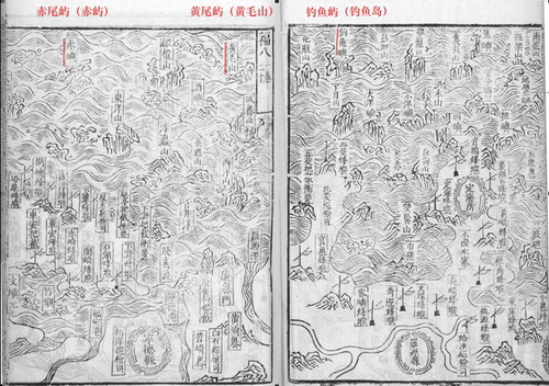
The Map in An Illustrated Compendium of Maritime Security(1561)
To the contrary, Japan’s old maps never marked the Diaoyu Islands within its territorial jurisdiction, a fact that is also sufficient to demonstrate that these islands were never possessed by Japan in the history. Even Japanese maps published after it annexed China’s Ryukyu Islands in 1879 and then renamed it Okinawa, such as the ones published in 1883 (The Atlas of the Great Japan) and 1885 (The Atlas of Okinawa Prefecture), did not mark the Diaoyu Islands, demonstrating that the Diaoyu Islands, Huangwei Island and Chiwei Island were never affiliated to the Ryukyu Islands.
In the 19th century, the maps published by Britain, France and the United States all recognized the Diaoyu Islands as a part of China’s territory. In a map drawn by a French geographer in 1809, the Diaoyu Islands, Huangwei Island and Chiwei Island were marked the same color as China’s Taiwan Island, an explicit implication that they were recognized subordinate to Taiwan. The Chinese maps published by Britain and the US respectively in 1811 and 1859 also listed the Diaoyu Islands in China’s territory. In a map published by the British Navy in 1877 on China’s maritime landscape from Hong Kong to the Gulf off East Liaoning Province, the full landscape of China’s maritime geography in the East China Sea was demarcated and the Diaoyu Islands were marked as affiliated to Taiwan. In the map, the Diaoyu Islands were also unambiguously separated from Japan’s Ishigaki Island by a demarcation arc running through its Sakishima Islands. This is also an indication that Japan’s Sakishima Islands do not include China’s Diaoyu Islands. The extensive application of this map in international exchanges in the following years showed wide international recognition that China holds an indisputable sovereignty over the Diaoyu Islands.
After the end of World War II, Hammond World Atlas Corporation, one of the world’s most famous map and atlas publishers of the 20th century, published a map in 1947 on Japan, Korea and Ryukyu Islands, which also indicated that the Diaoyu Island and its affiliated islands do not belong to the Ryukyu Islands, thus naturally do not belong to Japan.
 New type of urbanization is in the details

Copyright 1995 - . All rights reserved. The content (including but not limited to text, photo, multimedia information, etc) published in this site belongs to China Daily Information Co (CDIC). Without written authorization from CDIC, such content shall not be republished or used in any form. Note: Browsers with 1024*768 or higher resolution are suggested for this site.
License for publishing multimedia online 0108263 Registration Number: 130349 ![]()