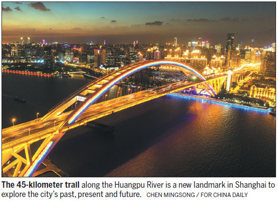
Riverfront trail offers chance to see city in new perspective
If you are looking for a good way to explore Shanghai's past, present and future, then the 45-kilometer waterfront trail along the Huangpu River can hardly be beaten.
The trail, comprised of walking, jogging and cycling lanes, was opened to the public earlier this year. It meanders through five districts from a northern terminus at the Yangpu Bridge to its southern end at Xupu Bridge.
Shanghai's industrial past can be seen along the 2.8-km section in Yangpu district, where foreign-built mills and a shipyard are located. There's also the city's first water plant, which is still operational today - more than 100 years after it was built. Refreshments are available from nearby pubs that of er great food and beer.
At the 2.5-km section of the trail in Hongkou district, the futuristic skyscrapers of Shanghai's Lujiazui financial area can be seen.
In Huangpu district, meanwhile, there are stunning views of old Shanghai such as the Waibaidu Bridge, China's first full-steel bridge that was built in 1908. Also included in this 3.2-km section is The Bund, a famous part of the city's waterfront with more than 50 foreign-style buildings, all of which are more than a century old.
Elsewhere, an 8.9-km section of the trail through Xuhui district links an array of museums and art galleries. The Yuz Museum was formerly an aircraft hangar, the Long Museum used to be a coal-loading dock, while the Star Museum was a railway station.
By 2020, there are expected to be 10 museums open to the public along this section, according to Chen Zihan, a landscape designer at the West Bund Group - the main developer of Xuhui district's riverside.
In Pudong New Area on the east bank of the Huangpu River, visitors can look on in awe at modern Lujiazui, home to the famous Oriental Pearl Tower and the more recent Shanghai Tower.
To help raise awareness of the trail, the Shanghai Surveying and Mapping Institute released a map of it on Chinese WeChat account Tusushanghai last year. The map helps visitors locate attractions, restrooms and public transportation along the trail.
"I took my 5-year-old daughter for nighttime walks along the Yangpu, Hongkou, Huangpu and Pudong sections during the weekends this summer, and the experience and nighttime views were fascinating," said Yang Yi, a resident who lives in Shanghai's Yangpu district.
"Sometimes, young kids will ask questions about the city they live in, but it is difficult to explain without real experiences. Now, things are getting easier."
Yang's daughter also enjoyed the ferry trip from the Yangpu to the Pudong sections of the trail, because it taught her that "ferries used to be a major mode of transportation in Shanghai before the Huangpu River's bridges and tunnels were built", he said.