China launches hi-res SAR imaging satellite
 |
|
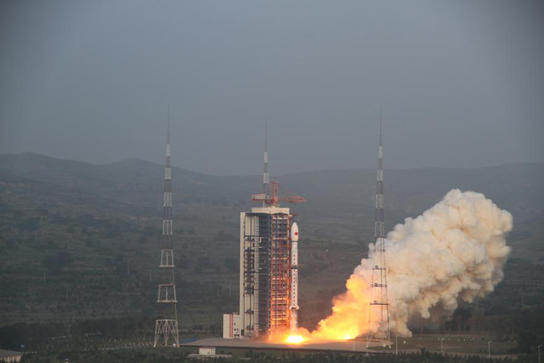
The Gaofen-3 satellite is launched off on the back of a Long March 4C rocket at 6:55 am at the Taiyuan Satellite Launch Center in northern Shanxi province on August 10, 2016. [Photo/Xinhua] |
TAIYUAN -- China launched a new high-resolution Synthetic Aperture Radar (SAR) imaging satellite from the Taiyuan Satellite Launch Center in northern Shanxi province on Wednesday.
The Gaofen-3 satellite was launched off on the back of a Long March 4C rocket at 6:55 am Beijing time, according to the center. It was the 233rd flight mission by a Long March carrier rocket.
As China's first SAR imaging satellite that is accurate to one meter in distance, it covers the globe with an all-weather, 24-hour observation service and will be used for disaster warning, weather forecasting, water resource assessments, and the protection of maritime rights.
Compared with optical imaging satellites, Gaofen-3 will better perform disaster monitoring as the SAR imaging satellite is capable of imaging in severe weather conditions as it uses microwave transmission.
"The launch of Gaofen-3 is expected to reduce dependence on data provided by foreign microwave imaging satellites," said Jiang Xingwei, deputy chief engineer of Gaofen satellite application system.
With 12 imaging modes, Gaofen-3 has the most imaging modes in the SAR imaging satellite family. The high-definition observation satellite is capable of switching freely between various imaging modes, taking wide pictures of both earth and sea, and detailed photographs of specific areas.
According to Yu Weidong, deputy chief engineer of Gaofen-3 satellite system payload, Gaofen-3's spatial resolution ranges from one meter to 500 meters and its largest viewing swath is 650 kilometers.
With a one-meter resolution, Gaofen-3 has the highest resolution among its kind, which enables the satellite to provide clear images of all roads, buildings and boats.
Gaofen-3 is also China's first low orbit remote sensing satellite to have a lifespan of eight years, longer than other China-built satellites, which have a lifespan of three to five years, and that of foreign models between six to seven-and-a-half years.
The new satellite is able to provide high-definition remote sensing data over long periods of time. It can capture continuous imaging for nearly one hour during ocean observation.
Since the inception of the Gaofen project in 2013, China has had an increasingly clearer view of the planet.
Launched in April 2013, Gaofen-1 can cover the globe in just four days.
Gaofen-2, sent into space in August 2014, is accurate to 0.8 meters in full color and can collect multispectral images of objects 3.2 meters or longer in length.
Gaofen-4, launched in late 2015, is China's first geosynchronous orbit high-definition optical imaging satellite and the world's most sophisticated.
The Gaofen-3 and the Long March 4C rocket were developed by the China Academy of Space Technology and the Shanghai Academy of Spaceflight Technology, under the guidance of the China Aerospace Science and Technology Corporation.
- Agreement for BeiDou Naviation Satellite System data center signed
- China launches first mobile telecom satellite
- From hunting wild fruits to satellite dishes: Life of Myanmar returnees
- Joint Sino-French satellite to study ocean waves, wind
- China's Beidou navigation satellite system
- China launches 2nd Shijian-16 satellite


- Is it a thing? 10 odd jobs where you can make good money
- Message on a bottle: Mineral water company launches drive to find missing children
- Sun Yat-sen champion of national integrity, unity: Xi
- Four killed, two injured after house collapses in C China
- Cross-Straits forum held to commemorate Sun Yat-sen