Air force 'ignored' rising-sea warnings at $1b radar site
|
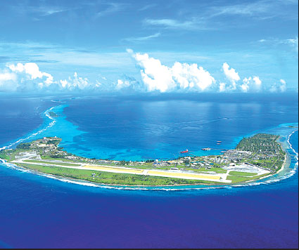
A US Army photo shows an aerial view of Kwajalein Atoll, where the Space Fence complex is being in the Marshall Islands. Us Army Via Associated Press |
The US Air Force is spending nearly $1 billion to build a radar installation that will help keep astronauts and satellites safe by tracking pieces of space junk as small as a baseball. That is, if global warming doesn't get in the way.
The Space Fence is being constructed on a tiny atoll in the Marshall Islands that scientists say could be regularly swamped by rising seas within a couple of decades as a result of climate change. The salt water could play havoc with the equipment, the scientists say.
And The Associated Press found that neither the military nor its contractor, Lockheed Martin, gave serious consideration to that threat when designing the installation and choosing a site, despite warnings from the island nation's environmental agency.
The future "does not look good for a lot of these islands," said Curt Storlazzi, an oceanographer with the US Geological Survey who is leading a study at Kwajalein Atoll, where the Space Fence complex is being built.
Dana Whalley, a civilian who is managing the Space Fence program, said that the radar installation has a projected lifespan of 25 years and that he doesn't expect sea levels to rise enough over that period to cause a problem. But if necessary, he said, the base could take steps to improve its seawalls.
Still, because of budget pressures, military equipment is often used well beyond its projected lifespan. In fact, a key part of the radar tracking system that the Space Fence replaces was built during the dawn of the space age and was badly outdated by the time it was shut down 50 years later in 2013.
Midway between Hawaii and Australia, the Marshall Islands are specks of land that typically poke just a few meters above the Pacific Ocean, making them some of the world's most vulnerable places to rising seas.
The US military has a longstanding connection to the islands. Bikini Atoll was used as a nuclear test site after World War II. Kwajalein Atoll, a battle site during the war, is now an Army base, a ballistic missile test site and an important part of the military's space surveillance network.
The growing problem of space debris was highlighted in 2009, when an old Russian satellite smashed into a commercial US satellite, creating hundreds of pieces of orbiting junk. The 2013 movie Gravity dramatized the threat to astronauts, who need to be safe from debris whether they're traveling on the International Space Station or in a rocket.
Lockheed Martin won the $915 million Space Fence contract in 2014 and broke ground last year. When the radar system becomes operational in late 2018, it should increase the number of objects that can be tracked tenfold to about 200,000 and provide more precise information on their orbits.
However, Storlazzi said rising sea levels could submerge the island at least once a year, damaging power cables, sewer lines and other electronics and hardware.
The study, funded primarily by the Defense Department, has not yet been peer-reviewed or published. But it paints a much more dire future for the atoll than earlier studies.
"We are talking the next couple of decades, not centuries, as previously thought," Storlazzi said.