Local satellite system becomes large-scale commercial success
|
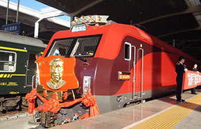
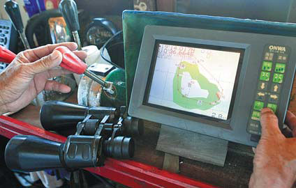
Chen Yiping, captain of fishing boat Qiongqionghai 03889, uses Beidou navigation to guide the vessel to Huangyan Island for fishing. Huang Yiming / China Daily |
China's domestic-made Beidou navigation satellite system has been put into large-scale commercial use, with its chips embedded in 40 million smartphones, the director of the national satellite navigation said on Wednesday.
Ran Chengqi, director of the China Satellite Navigation Office, said that more than 2 million of China's independently developed BDS modules had been sold by the end of March.
"The Beidou system has also been adopted in more than 20 vehicle brands in China, which include more than 200 models," Ran said at the 5th China Satellite Navigation Conference. The event in Nanjing, Jiangsu province, was held from Wednesday through Friday.
"With the improvement of chip size, power consumption and production cost, the BDS will be more widely used in people's daily lives, both at home and abroad."
In addition, more than 300,000 vehicles in the country have been installed with BDS terminals following the Transport Ministry's stipulation in 2013 that all bus tour charters and vehicles carrying hazardous materials should have them.
Beidou is the Chinese name for the constellation The Big Dipper, which has been used by people since ancient times to tell direction.
China launched its first BDS satellite in 2000. The country now has 16 satellites and will launch newer navigation satellites near the end of this year, the satellite navigation office said.
While the satellites in use have a life expectancy of about eight years, the newer navigation satellites are expected to work for up to 15 years.
The number of satellites to be launched is expected to grow to 40 in six to eight years to form global coverage. The BDS now covers the Asia-Pacific region and has provided services like positioning, navigation and timing to civilian users in a number of Southeast Asian nations since December 2012.
"The BDS has achieved the same accuracy as GPS, developed by the US, in all-weather positioning and timing," said Li Guangxia, a professor of communication engineering from the PLA University of Science and Technology.
When the BDS system is complete around 2020, its positioning accuracy will be improved from the current 10 meters to about 2.5 meters, the satellite navigation office said. With the support of ground-based augmentation networks, the accuracy will be further improved to within centimeters.
"Compared with other satellite navigation systems, the BDS is particularly suitable for group users to launch large-scale monitoring and management," Li said.
The world's satellite navigation market is now dominated by four systems - the US' GPS, Russia's GLONASS, the EU's Galileo and China's BDS.
By 2020, growth of the global navigation market, which sees a 10 percent annual increase, will be $220 billion, the European GNSS Agency has estimated.
Global customers will be able to receive free positioning and navigation services from Beidou and GPS with a dual-mode receiver after the system is completed by 2020.
Contact the writers at cangwei@chinadaily.com.cn and songwenwei@chinadaily.com.cn