 |
|
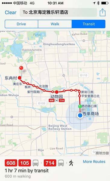
The travel route from Xidan's Apple Store to Aloft Hotel is highlighted by Apple Maps in a screenshot taken on August 12, 2015. [Liu zheng / chinadaily.com.cn] |
Whether traveling within a city or across the country, Apple Maps will provide detailed routes including bus stops, subway stations, ferry terminals, train stations and the walking distance between different forms of transport.
It also provides customized options for users to choose departure date and time to calculate an optimal travel solution.
When you need to get off your bus to get to the next leg of your journey, the app will prompt you ahead of time in case you miss your stop.
Compared with the original Gaode maps, which had voice search input and estimated fare functions for public transit, Apple's maps make use of its voice-activated assistant, Siri, to support the audio search while no specific commuting fees will be shown for any planned routes.
And of course, there are still shortcomings to be improved, for example information about flight services is so far not provided and the potential value of online to offline businesses that could be listed on Location Based Services has not been explored at this moment.
Introduced in 2012, Apple Maps, which aims to replace Google Maps, the previous default mapping application for iPhone, iPad and Apple computer users, comes preinstalled in the iOS, OS X and watchOS operating systems.
Copyright 1995 - . All rights reserved. The content (including but not limited to text, photo, multimedia information, etc) published in this site belongs to China Daily Information Co (CDIC). Without written authorization from CDIC, such content shall not be republished or used in any form. Note: Browsers with 1024*768 or higher resolution are suggested for this site.
License for publishing multimedia online 0108263 Registration Number: 130349 ![]()