|
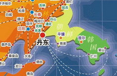
Dandong sits in the center of Northeast Asia, where the Yalu River and Yellow Sea meet, southeast of Liaodong Peninsula’s open zone. It is an important assembly point for Northeast Asia’s economic rim and the Bohai Sea economic rim, and has unique coastal, riverine, and continental advantages.
It faces the town of Sinuiju in the Domestic People's Republic of Korea across the Yalu, with the Yellow Sea to the south, extends to Anshan and Yingkou to the west, neighbors Dalian to the southwest, and borders Benxi in the north. Dandong covers a total of 15,222 sq km and has 120 km of coastline, with the Dalu and Xiaomai islands lying just off coast.
Annual temperatures averages 6.8-8.7℃. The winter freeze is relatively short, as is the hot summer, which generally lasts for 20 days or so (late July to mid-August).
Dandong has some of the heaviest precipitation for the Northeast, with the annual rainfall averaging 800-1,200 mm. Two-thirds of the precipitation comes in the summer, with late July to mid-August taking the brunt of it.
The Dandong area is dotted with rivers and has 944 small to large rivers and streams longer than 2 km. There are four major rivers with a more than 5000-sq-km watershed: the Yalu, Hun, Ai, and Dayang.
Dandong lies in a mountainous and upland part of Liaodong with Changbai Mountain gradually sloping downward from northeast to southwest.
|