 Satellite photos show quake-hit Beichuan County
(Agencies)
Updated: 2008-05-22 10:40
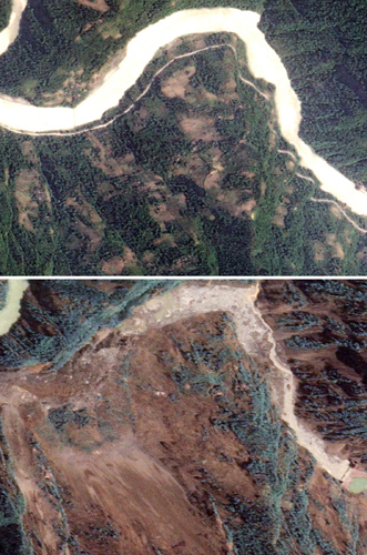
This newly released pair of images shows the affects of the May 12, 2008 earthquake near Chengdu, China. The top image shows the tree-covered mountain terrain of China's Beichuan County on May 14, 2006. A river curves along the base of the mountain, and a road follows the banks of the river. The lower imaged, seen on May 14, 2008, shows the landscape almost unrecognizable where a landslide engulfed the entire mountainside, turning its green slopes brown. Both the road and the river are entirely gone, buried under the rubble, which rises in a mound up the opposite slope. Landslides and buckled roads have made travel within quake-affected regions difficult. [Agencies]
|