Reaching the breaking point
Updated: 2008-05-21 07:17
|
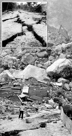
A giant crack left by the Wenchuan earthquake at the Beichuan Middle School site. Inset: Fissures in the wake of the Tangshan quake in 1976. Guo Jianshe and Wang Wenlan |
Residents living in the mountains of Sichuan are used to earthquakes. A strong earthquake with the magnitude of 7.2 on the Richter scale hit the province's northwest corner from Songpan to Pingwu 32 years ago.
However, the Wenchuan earthquake, with its frequent aftershocks, is simply stunning in its power and scale, especially when it is compared with the 1976 great Tangshan earthquake - with a magnitude of 7.6 on the Richter scale - which killed 240,000 people and leveled the medium-sized industrial city.
In addition to the fact the Wenchuan quake registered a higher magnitude, 8 on the Richter scale, the tremor lasted two to three minutes, longer than the Tangshan quake, according to Ma Mei, a leading geologist with the China Academy of Geological Sciences.
And comparing the source strength and extent of the fault movement in between the two quakes, Wenchuan's was more than triple that of Tangshan.
It goes without saying that the Wenchuan earthquake has ravaged a far larger area than Tangshan, with the earthquake rupturing mountains and caused extensive landslides.
But how did this happen?
According to geologists, the earth's surface is fractured into more than a dozen or so large plates. As the plates move ceaselessly and the boundaries between these plates or faults often lock into or grind against one another until they can no longer withstand the strain. At that point, the plates slip and release energy, causing in an earthquake.
China stands on the Eurasian Plate, with the Indian Plate at its south.
Around 40 million years ago there was an ocean where the Himalayas are today. And the "roof of the world", the Qinghai-Tibet Plateau, was a warm land covered by lush plants and lots of animals.
Starting 240 million years ago, the Indian Plate separated itself from Gondwanaland, one of the two earth's two original continents, moving toward its current location. This movement has not only made the highest mountain in the world, but also created an active earthquake belt.
After 240 million years of movement, the Indian Plate has driven deeply into the Eurasian Plate. The Qinghai-Tibet Plateau, the highest and widest in the world, is where these two plates overlap. Volcanoes and unsteady mountains show this movement is ongoing.
The current speed is about 5 cm per year. "There is a continuous accumulation of a massive amount of energy during this movement, which cracks the surface of the earth at the weakest part when it reaches a certain intensity," said Zou Wenwei, director of the bureau's publicity and education department.
The movement of the Indian Plate seems to have accelerated suddenly in recent years. From 2001, three big earthquakes have occurred around this plate. On Nov 11, 2001, a magnitude-8.1 earthquake struck the western Kunlun Mountains, a sparsely populated area. On Dec 26, 2004, a magnitude-9 earthquake took place 160 km west of the Indonesian island of Sumatra Island, causing the tsunami that claimed around 230,000 lives.
Sichuan is also one of the most earthquake-prone zones in China.
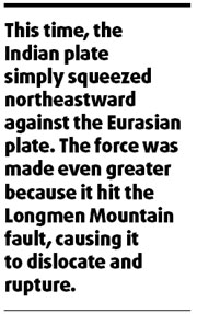
Looking at a geological map of this area, even the layman can see the numerous faults on the earth's surface. Moreover, it sits over a part of the eastern Qinghai-Tibet Plateau on the edge of the Eurasian plate and the Chengdu plain. In between the plateau and the plain is the famous 200 km-long Longmen Mountain fault. Along the mountain's two sides, the altitude lifts from 700 m to 4,000 m. Considering its width ranging between 15 and 20 km, it is the steepest mountain around the plate.
Wenchuan, a small county in west Sichuan, is located in Longmen Mountain area.
This time, the Indian plate simply squeezed northeastward against the Eurasian plate. The force was made even greater because it hit the Longmen Mountain fault, causing it to dislocate and rupture.
Li Yong, a professor at Chengdu University of Technology, studied this area, and his research shows Longmen Mountain has been lifted by 11.2 to 12.6 km throughout history. It continues to rise at a speed of 0.3-0.4 mm per year.

Meanwhile, the Qinghai-Tibet Plateau is also being raised and moving eastward, and at a higher speed. These facts indicate the rise of Longmen Mountain is the result of the crush from its western side. With the continuing movement of the Indian Plate, the pressure is increasing on Longmen Mountain. One day the rocks in the mountain will be unable to bear this, resulting in an earthquake.
In the last 100 years, 14 big earthquakes of a magnitude greater than 5 happened in Longmen Mountain. Between these big earthquakes, thousands of small tremors have shaken this area almost every day. The last big earthquake in Wenchuan happened in 1657.
Zou said he expects the aftershocks in Sichuan will continue.
"Aftershocks after the Tangshan earthquake, for example, lasted for years," he said. "When the earth's surface cracks, the old structural balance is broken, and the earth is trying to find a new balance. The process of adjustment is when aftershocks happen."
He believes that data from the Sichuan earthquake will greatly assist Chinese seismologists future work.
(China Daily 05/21/2008 page9)
|
||
|
||
|
|
|
|