
"We thought it would take one month to complete the expedition because we needed to cross the three rivers, as well as the divides and watersheds in between, to see all of them. At that time there was no highway connecting the rivers," he says.
However, no matter how big the sites are, UNESCO allows, at most, two-week investigations.
With the help of local people, they planned an east-west route that started from the Jinsha River and ended west of the Gaoligong Mountains located on the west bank of the Nujiang River.
"We tried everything. If there was a highway, we took off-road vehicles. If there was no highway, we rode horses, and if even horses couldn't go on, we went on foot," he says.
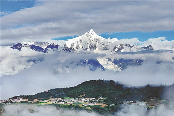
It was a hard expedition. In the area, a world of sierras, stand 118 glaciated peaks of more than 5,000 meters above sea level. The highest is Kawagebo Peak (6,740 meters) in Dechen county of Dechen Tibet autonomous prefecture, in the Lancang River Grand Canyon. This protected area is inhabited by the endangered Yunnan snub-nosed monkeys.
Liang remembers how the weather kept changing when they climbed over the Biluo Snow Mountains located in the Lancang-Nujiang divide. Biluo's snowcapped range extends 142 km with 15 glaciated peaks measuring over 4,000 meters above sea level. The 4,500-meter-high Laowo Mountain stands out as the most beautiful. Elevation drops 3,200 meters before reaching the Lancang River.
"At some points, we very cautiously rode horses along narrow roads on the cliffs. Actually, when we prepared for the expedition, several people were injured while trying the dangerous roads," he says.
The expedition lasted 12 days. When the experts departed, one of them, Canadian Jim Thorsell, gifted Liang a book.
It was a copy of an excerpt from The Mystery Rivers of Tibet by British botanist and explorer Francis Kingdon-Ward, who traveled across the three parallel rivers and the watersheds in 1913 to collect plant species for British horticulture businesses and scientific research.
Liang found their route overlapped in many respects with the one Ward traveled nearly 90 years prior.
"Thorsell read the book and told me the natural conditions of the area had not changed much over the years," Liang says.
Ward devoted the whole fifth chapter to the sacred mountain of Kawagebo. It was also a waypoint on the UNESCO expedition.
Kawagebo and other glaciated peaks, such as Biluo, Baima and Haba snow mountains, represent the spectacular beauty of the site.
In addition to the magnificent skyline of the glaciers, the area is also granted with other outstanding scenic landforms, such as alpine karst, especially the Stone Moon above the Nujiang Grand Canyon, and the "tortoise shell" of the alpine Danxia, a landform characterized by its reddish sandstone features.
As elevation drops from over 6,740 meters to 760 meters, the area presents every kind of natural view in the Northern Hemisphere except those of oceans and deserts-glaciers, alpine valleys, alpine lakes, alpine meadows, broad-leaved and coniferous forests, and so on.
Having witnessed a literal sea change, the area is a museum of geology, housing a collection of diverse rock types, such as alpine sandstone landforms, granite monolith and a range of karst formations.
Despite bordering tropical Myanmar to the west, the area provides various climates for creatures living in subtropical, temperate and frigid zones, making it the region with the richest biodiversity in China.
Such unique geographical locations, and hydrogeological and weather conditions create diverse atmospheres, which are summarized by the local people as "the weather changes every five kilometers".
Being located at the juncture of East Asia, Southeast Asia and Qinghai-Tibet Plateau, the area not only provides a corridor for the migration of species, endemic or otherwise, but also preserves species that can rightly be called living fossils-for example, the Cyathea tree ferns which hark back to the time of the dinosaurs.
The area, described by locals as "tens of thousands of creatures living on one mountain", shelters more than 20 percent of higher plant species (of relatively complex or advanced characteristics) and 25 percent of animal species in all of China.
For example, the big tree rhododendron is native to the Gaoligong Mountains. Since 2015, people have sought to cultivate the critically endangered plant. The good news is that 60 percent of the 80 saplings planted in the wild in 2017 have survived. So have the 200 saplings planted in May last year.
Apart from fauna and flora, the area is also home to 16 ethnic groups, including Tibetan, Lisu, Bai, Pumi and Derung, who, regardless of having different languages, cultures and traditions, live harmoniously together.
Today, as more creatures perish at an ever-increasing speed around the world, in the inaccessible mountains of the Three Parallel Rivers of Yunnan Protected Areas, new species are discovered, almost every year. This, alone, makes it an authentic natural wonder.


