
Launch a shot in the arm for Jilin
By Liu Mingtai ( China Daily )
2015-10-15
China recently launched four Earth-observing Jilin-1 satellites to provide photographs for commercial clients and the public.
The group of satellites, named after the northeastern province of Jilin, were launched from the Jiuquan Satellite Launch Center in the Inner Mongolia autonomous region on Oct 7, becoming the country's first high-resolution remote sensing satellite system for commercial purposes.
On Saturday, the satellite system transmitted its first pictures to ground control, said Jin Guang, deputy chief designer of the Jilin-1.
Once the satellites become fully operational, they will produce high-definition images, which will play an important role in a range of fields, such as the monitoring of climate change as well as land and mineral resources; geographical mapping; the construction of transport infrastructure; agriculture; disaster relief; and emergency response, Jin said.
Developed by the Changchun Institute of Optics, Fine Mechanics and Physics under the Chinese Academy of Sciences, the four Jilin-1 satellites are operating on a 656-kilometer sun-synchronous orbit with different missions.
The 430-kilogram major satellite is a high-definition optical and Earth-observing satellite carrying a 0.72-meter-resolution, pan-chromatic camera and a 2.88-meter-resolution, multispectral camera. It is responsible for monitoring designated places and generating high-definition images.

A computer rendering shows how the satellites will travel on their 656-kilometer sun-synchronous orbit. [Photo by Zou Naishuo/China Daily]
Two 100-kg video satellites are designed to capture videos with an ultra-clear resolution while the 55-kg satellite is used for testing imaging technology.
The launch of the Jilin-1 indicates Jilin province, one of the country's oldest industrial bases, has made huge strides in space science, communications and equipment manufacturing, said Xuan Ming, board chairman of Changguang Satellite Technology Co Ltd, a business entity founded by the Changchun institute responsible for the satellites' commercial operations.
Starting from scratch
A decade ago, the province knew next to nothing about developing satellites, though the Changchun Institute of Optics, Fine Mechanics and Physics had taken part in China's manned space and lunar exploration programs by developing spacecraft-borne apparatuses. Nearly all of China's satellites had, up until that time, been developed by the China Aerospace Science and Technology Corp, the major contractor for the country's space activities.
In 2005, the Changchun institute began an initiative to design satellites.
"In the past, our designers would develop a satellite's components on a given platform according to a client's requirements. Now we are developing our own satellites on our own new platform," said An Yuan, a senior engineer at the institute.
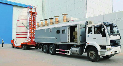
The Jilin-1 satellites are delivered to the Jiuquan Satellite Launch Center in Gansu province. [Photo by Zou Naishuo/China Daily]

The Long March 2D rocket blasts the four Jilin-1 satellites into space. [Photo by Zou Naishuo/China Daily]
The institute's new platform substantially reduces the satellite's weight, size and production costs while improving their reliability and efficiency, he added.
"With our new designs, a satellite can be nearly 40 percent lighter than others that were made using traditional designs, which means one single launch can send a number of satellites simultaneously," An said.
Recognizing the market potential behind the new technology, the institute established a research center in 2008 for small satellite technologies.

Researchers and engineers at ground control closely monitor the launch of the satellites. [Photo by Zou Naishuo/China Daily]
In 2012, the Harbin Institute of Technology joined the project. It became a national research center later that year, coinciding with the development of the Jilin-1 satellite system.
But researchers soon ran into the major challenge of developing a video satellite - Chinese engineers had never done research on such a craft, which had only been developed by the United States.

The satellite's lightweight design allows the group of satellites to be carried by a single rocket. [Photo by Zou Naishuo/China Daily]
Led by Wang Jiaqi, an academician at the Chinese Academy of Sciences, a group of young engineers spent about a year and a half on numerous experiments and calculations before creating the cutting-edge satellite.
Jin said the video satellite is able to continuously record a target on the ground for two minutes and then transmit the video to the ground at a rate of 130 megabytes per second. He claims that the videos can be seen in near real-time.
Unwavering support
Part of the project's success is a result of the Jilin provincial government's unwavering support.
The government named the Jilin-1 as a priority in its annual work report for four consecutive years since 2012, vowing to build a strong space industry within the province.
Bayinchaolu, the provincial Party chief, and Governor Jiang Chaoliang have repeatedly expressed their support of the project, saying they hope the satellite sector could inject new momentum into the regional economy and boost innovation.
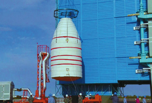
The Long March 2D rocket carrying the satellites is loaded onto the launch pad. [Photo by Zou Naishuo/China Daily]
According to satellite experts, although China has had a number of weather and Earth observation satellites, a great proportion of space-generated images and data it uses still comes from foreign satellites because only a small number of Chinese satellites are able to produce around-the-clock, high-definition images.
This situation means satellites like the Jilin-1 will have a bright market prospect and many lucrative opportunities, they said. Foreign nations have already expressed interest in using data and images from the Jilin-1 satellites.
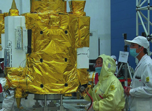
Experts from the Changchun Institute of Optics, Fine Mechanics and Physics perform a final check of the satellites before the launch. [Photo by Zou Naishuo/China Daily]
Recently, the Changchun institute signed a cooperation agreement with three users including the National Administration of Surveying, Mapping and Geoinformation to exploit Jilin-1's data products, according to information released by the institute.
The institute's Changguang Satellite Technology Co Ltd is planning to invest about 3 billion yuan ($473 million) to establish a space industry park in the province in the near future.
The provincial government has decided that the satellite industry should act as a new economic driver. Jilin expects to launch 60 satellites by 2020 and 138 by 2030.
In 2016, Jilin province plans to send 12 satellites to form a network with the four Jilin-1 satellites already in orbit.
From 2030 the province's satellite system will have 138 satellites in orbit, creating an all-day, all-weather, full-spectrum data acquisition capability that can generate the world's top space information products.