NASA obtains best images of moon's south pole
Updated: 2008-02-29 09:56
NASA said Wednesday that it has obtained the best images of the moon's rugged south polar region, with a resolution to 20 meters per pixel, according to media reports Thursday.
NASA's scientists also said that the region, a possible future landing site for human or robotic lunar missions, is far more rugged than has been thought, with towering peaks and deep craters.
|
|
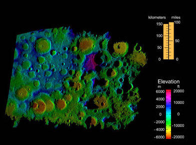
"The south pole of the moon certainly would be a beautiful place to explore," said Doug Cooke, deputy associate administrator for the Exploration Systems Mission Directorate at NASA Headquarters, Washington.
"We now know the south pole has peaks as high as Mt. McKinley and crater floors four times deeper than the Grand Canyon," said Cooke, adding, "There are challenges that come with such rugged terrain, and these data will be an invaluable tool for advance planning of lunar missions."
Scientists from NASA's Jet Propulsion Laboratory in Pasadena, Calif., collected the most accurate, highest-resolution terrain mapping data to date on the moon's south pole using the facility's Goldstone Solar System Radar located in Mojave Desert.
The images have shown an area around the Shackleton Crater, with some terrain in perpetual darkness and other areas almost always sunlit. The Shackleton rim area is considered a candidate landing site for a future human mission to the moon.
Previous measurements by spacecrafts to visit the moon indicated that water ice might exist in darkened areas of the crater.
If ice does exists, it could provide a useful resource for astronauts, for water as well as for fuel if the water is broken down into hydrogen and oxygen, said Cooke.
|
|
|
||
|
||
|
|
|
|