City maps out the future of 'total tourism'


A map carved on a cliff of Yingwu Hill in the north of Guilin in Guangxi Zhuang autonomous region records the advanced water system of the city during the Song Dynasty (960-1279).
The masterpiece that was carved some 700 years ago, later called The Map of Jingjiang Prefectural City, is the earliest example of city planning in China.
It is also where the inspiration came from for today's ecological Two Rivers and Four Lakes project, China's first demonstration area for all-region tourism in the country.
As one of Guilin's calling cards, the project, which covers some 6.15 million square meters, connects the city's Taohua and Lijiang Rivers in the east to four inland lakes - Ronghu and Shanhu Lakes in the south, Guihu Lake in the east and Mulonghu Lake in the north.
Encircled by rivers, lakes and mountains, the downtown area of Guilin forms a unique landscape studded with wharfs, boats, bridges, pavilions and both traditional and modern architecture.
"It is a mixture of nature, traditions and modernity. The project has become the essence of Guilin, making the city the 'Oriental Venice'," said Jiang Yuliang, Party chief of Xiufeng district in the city.
He added that boat tours along the water route allow passengers to dream of the city's prosperity during the Song Dynasty, as they pass thousand-year-old banyan trees on the shore, as well as caves, Buddhist pagodas and gate towers. The rivers and lakes project covers such diverse elements as environmental protection, architecture, gardens and trees, mountains and rivers, local customs and ethnic cultures.
With investment of 100 million yuan ($15.15 million), the local government initiated the project in 1999 and completed the first phase in 2002.
"Focusing on the ecological environment and infrastructure, it was first constructed as a public welfare project for local residents. And upon completion, the project became an area for green development.
"The project encountered many obstacles in the beginning - one of which was the need to clear silt from the lakes," Jiang said. Over the years, sediment washing into the lakes has continually raised the bottom level.
The government used such tools as hydraulic blowers and a long-distance pipeline to transport the silt to storage yards 13 kilometers outside the city.
In total, 600,000 cubic meters of silt was removed from Ronghu, Shanhu and Guihu Lakes.
The need to clean up Mulonghu Lake, the only manmade lake in the project, created another problem, as it had deteriorated into a mixture of stagnant ponds and buried channels.
Luo Jianzhang, director of the Guilin Tourism Development Committee, said the project is key to the city's all-region tourism plan. "From boating to walking, visitors will be able to enjoy both the natural views and cultural sights around the lakes and, at the same time, the restaurants, hotels and shops along the rivers," Luo said.
He added that Guilin has changed its tourism model from a scenic-spot-centric one to an all-region version by upgrading its resources, industries, natural environment and public services. "A vital part of all-region tourism in Guilin is combining ethnic cultures with rural landscapes and features such as ethnic villages and Impression Liu Sanjie (a play that used the Lijiang River as a stage)," Luo said.
wangjinhui@chinadaily.com.cn
|
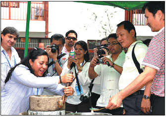
Lujia village in Xiufeng district in Guilin is now a popular cultural tourism zone for visitors from home and abroad.Tang Shunsheng / For China Daily |
|
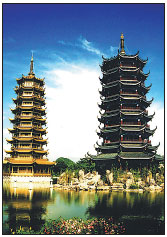
The Sun and Moon pagodas at Shanhu Lake in Guilin.Provided To China Daily |
(China Daily 10/18/2016 page12)