Xing'an: Waterway tells the tale of ancient town
Lingqu Canal, the lifeblood of the county, helped unify South China
Xing'an county in Guilin, in Southwest China's Guangxi Zhuang autonomous region, is a 2,000-year-old town.
The first emperor of the Qin Dynasty (221-206 BC) built the town and Lingqu Canal in 221 BC.
The emperor started wars against local tribes in South China after reuniting Central China. The long and rugged roads from the north to the south became a headache for him, because he needed to send more troops and military supplies to South China.
He ordered an engineer, Shi Lu, to dig a canal to solve the issue. After intensive research, Shi drew a line on the map connecting Xiangjiang River, which flows to the north and enters the Yangtze River, and Zhujiang River, which meanders to the south and converges with the Pearl River.
Shi ordered soldiers to follow the line he drew to dig the 37-kilometer-long canal, which was called Lingqu. The Qin army used the waterway to transport supplies and people, which helped unify South China.
Because of the canal, Xing'an was transformed from a small village, where Qin army families who were assigned to look after the canal lived, to a booming regional commercial and transport center. Businesspeople from the north and the south met in the town.
Hundreds of ports for various goods and agricultural products sprung up along the canal. The government set up a special tax department in Xing'an and sent troops to protect the area's wealth.
Xing'an's prosperity lasted nearly 2,000 years until the early 1940s, when a nearby road was built connecting Guilin with Wuzhou, a border town connecting Guangxi with its better-off neighbor Guangdong province.
However, Lingqu Canal continues to be an important irrigation source and waterway for local farmers today.
The canal was built at the same time as the Great Wall but is hardly known to people around the world, despite its lengthy service to people in the area.
Local people say Xing'an is a cultural melting pot, because the town's culture is inclusive and mixed compared to other counties in Guilin.
Maoer Mountain
Life in Xing'an is an eye-opening experience for many modern urbanites, who find a much slower pace of life is enjoyed in the area. Local residents are friendly and easy-going, with older people often eager to tell the stories of their families' business successes.
As well as the canal, another tourism attraction in the area is the 2,142-meter-high Maoer Mountain, the highest peak in South China and the source of three rivers: the Lijiang, Xunjiang and Zijiang, which all flow into the South China Sea.
The mountain is 55 km away from downtown Xing'an, and looks like a squatting cat, as its Chinese name literally depicts.
Travelers can catch a bus to the top of the mountain and enjoy the scenery along the 50-km-long winding road that circles up to the summit.
Botanists will particularly enjoy the journey, as different plants grow at levels up the mountain.
From the mountain's foot to about 1,200 meters, evergreen broad-leaf trees grow. Between 1,200 meters and 1,800 meters, deciduous evergreen broad-leaf mixed trees dominate, including rare plants. From 1,800 meters to 2,000 meters, evergreen broad-leaf and needle-leaf mixed forests grow before giving way to low brushes at the mountaintop.
The mountain was designated as a national natural reserve in 1999, when statistics show there were 112 rare animals and 1,436 rare plant species living there. These included hemlock, which is called a living fossil because of its long history.
The mountain was a huge challenge for the Red Army led by the Communist Party of China to pass on the legendary Long March in the 1930s.
The soldiers called it Yaoshan Mountain, because the only people who lived there at the time were the Yao ethnic group.
Some people fell from the cliff-like mountainside with their horses while they tried to escape the army of local warlords affiliated with the Kuomintang. A monument stands on one of the narrow mountain paths in memory of those who died there.
Another monument on the other side of the mountain commemorates soldiers from the United States who also died there.
In 1996, two local farmers discovered a crashed World War II B-24 bomber on the mountainside.
The bomber, which had a crew of 10, hit the mountain on the night of Aug 31, 1944, after bombing a Japanese fleet at Kaoshiung Port in Taiwan. The plane's wreckage was transported back to the US.
Lan Lin contributed to this story.
liyang@chinadaily.com.cn
|
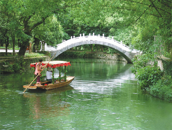
A boat glides on the south canal, a branch of Lingqu Canal, which was constructed in 221 BC. |
|
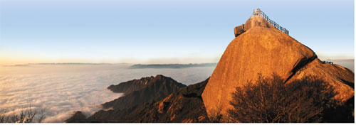
The peak of Maoer Mountain looks like a squatting cat, as its Chinese name literally depicts. |
(China Daily 05/28/2015 page7)