Hurricane Arthur makes landfall in North Carolina's Outer Banks
The first hurricane of the Atlantic season has hit the North Carolina coast, a wet and windy spoiler of the July 4th holiday for thousands of US citizens as authorities ordered them to evacuate exposed areas.
Hurricane Arthur crossed the coast near Cape Lookout at the southern end of North Carolina's Outer Banks at 11:15 pm EDT on Thursday, with maximum sustained winds of 160 km per hour. This earned it Category 2 status on the five-step Saffir-Simpson scale of hurricane intensity, the US National Hurricane Center said.
Arthur is the first hurricane to hit the United States since Superstorm Sandy devastated parts of New York and New Jersey in October 2012 and caused $70 billion in estimated damage.
|
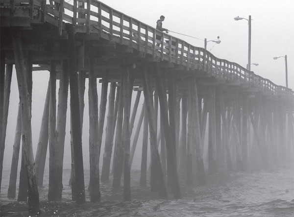
A man fishes from the Nags Head Pier as fog and heavy surf roll in, in North Carolina's Outer Banks, on Thursday. Arthur was the first hurricane to strike the United States since Superstorm Sandy in October 2012. Mark Wilson / Agence France-Presse |
As of early on Friday morning, Arthur was moving at about 37 kph as it headed oceanward about 20 miles east of Kitty Hawk, North Carolina, said National Hurricane Center meteorologist Chris Landsea.
"It's pushing offshore from the Outer Banks of North Carolina. It did not stay over land very long, and it did not traverse a lot of land," Landsea said, adding it lingered over Pamlico Sound for about six hours.
"It's expected to accelerate during the day as it passes southeast of New England," he said. It was expected to pass southeast of Cape Cod on Friday evening.
More than 20,000 customers were without power near North Carolina's coast as Arthur rushed through early on Friday morning, according to utility Duke Energy.
However, Arthur remained a medium-sized storm with hurricane-force winds extending outward only up to 65 km and lesser tropical storm-force winds to 240 km.
Little risk
After cutting through the Outer Banks, Arthur was moving northeastward over cooler water on Friday, diminishing in strength as wind-shear disrupted its structure and posing little risk to the densely populated northeastern US, Landsea said.
Tropical storm warnings would be in effect throughout Friday for eastern Massachusetts, including Nantucket. Arthur would be around western Nova Scotia in Canada early on Saturday.
The storm disrupted Independence Day festivities and fireworks for holiday beachgoers and others ordered off low-lying North Carolina barrier islands in its reaches.
Tourists and some residents packed ferries and crowded the only highway off Ocracoke and Hatteras islands, where voluntary and mandatory evacuations were in effect, though some people stayed behind to look after their homes.
Officials warned of life-threatening rip currents and a storm surge of up to 1.5 meters that could render the narrow 80-km Highway 12 connecting Hatteras Island to the mainland impassable.
Part of the highway was washed out by storm surge for two months after Superstorm Sandy, forcing people to use ferries to reach the mainland.
North Carolina was putting extra heavy equipment in place to remove sand and the overwash as soon as possible after Arthur passes. Hundreds of military and state police officials were deployed to help with storm preparation, safety and evacuation efforts.
(China Daily 07/05/2014 page7)