Mapping the truth of history
To fend off Japanese pirates (operating in the Chinese coastal waters from the 14th century to the 16th century), China had already included the Diaoyu Islands in its sphere of defence in the early Ming Dynasty. In 1561, the 40th year of the Jiajing Reign (1522-1566), Zheng Ruoceng, a famous Chinese strategist and geographer in the Ming dynasty, under the direction of Hu Zongxian, the supreme commander in charge of southeastern coastal defence, compiled a geographic and maritime defence document called An Illustrated Compendium of Maritime Security. The first volume of the historical document explicitly recorded diaoyuyu, huangmaoshan and chiyu, namely, today’s Diaoyu Islands, Huangwei Island and Chiwei Island, under the Ming imperial jurisdiction. The historical document is sound evidence that China had already placed these islands under its defence in the Ming Dynasty at the latest. China’s maps, published in 1579 (The Roadmap to Ryukyu) 1629 (The Records of Xiangxu in Ming Dynasty),1767 (The Atlas of Kunyu) and 1863 (The Atlas of the Great Qing Dynasty) all included the Diaoyu Islands and their affiliated islands in its territory.
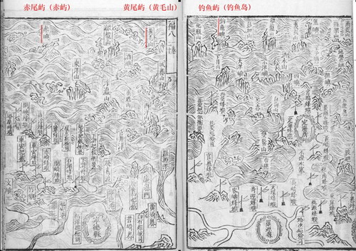
The Map in An Illustrated Compendium of Maritime Security(1561)
To the contrary, Japan’s old maps never marked the Diaoyu Islands within its territorial jurisdiction, a fact that is also sufficient to demonstrate that these islands were never possessed by Japan in the history. Even Japanese maps published after it annexed China’s Ryukyu Islands in 1879 and then renamed it Okinawa, such as the ones published in 1883 (The Atlas of the Great Japan) and 1885 (The Atlas of Okinawa Prefecture), did not mark the Diaoyu Islands, demonstrating that the Diaoyu Islands, Huangwei Island and Chiwei Island were never affiliated to the Ryukyu Islands.