China-Brazil satellite program reaches fresh frontiers

Brazil and China have huge continental territories and plenty of natural resources, which undergo continual transformations that are difficult to monitor. The daily monitoring of these resources and transformations, both natural as well as man-made, can be carried out more efficiently and economically when the Earth is observed from Space.
On July 6, 1988, in a joint effort to develop capacity in Earth Observation from Space, China and Brazil signed an agreement for the development and launch of two remote sensing satellites.
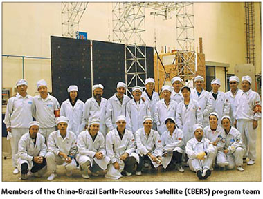
This was followed by the setting up of the China-Brazil Earth-Resources Satellite (CBERS) program, coordinated by the China National Space Administration (CNSA) and the Brazilian Space Agency (AEB), and executed by the China Academy of Space Technology (CAST) and the Brazilian National Institute for Space Research (INPE).
The CBERS program has witnessed the successful launch and operation of the two satellites and two nations signed another agreement on November 22, 2002 for the manufacture and launch of two new satellites - CBERS-3&4 - with improved characteristics. This new generation of Sino- Brazilian remote sensing satellites are to be launched in 2009 and 2011 respectively.
In order to avoid a data gap between CBERS-2 and CBERS-3, China and Brazil signed a complementary protocol on November 12, 2004 for manufacturing the CBERS-2B satellite, to be launched this month.
The CBERS program, a major model of successful "South-South Cooperation" in space technology is currently the only operational global land cover remote sensing program, with a data policy based on public good and data continuity until 2015.
Applications
CBERS are equipped with cameras for earth observation in different spectral bands. Each satellite also carries a transponder for data collection, to support the Brazilian Environmental Data Collection System. The CBERS-3&4 satellites will be equipped with a more sophisticated payload than those on onboard the CBERS-1&2 satellites.
These remote sensing satellites have brought significant scientific advances to Brazil. Over 15,000 users from more than 1,500 organizations are registered as active CBERS users, while 300,000 CBERS images are distributed at the approximate rate of 250 every day.
Its images are used in important areas such as fire control in the Amazon region, water resources monitoring, urban growth, land use and education.
CBERS inputs are crucial for large national and strategic projects in Brazil, like PRODES - Amazon annual deforestation rate evaluation, DETER - Amazon deforestation real time detection and CANASAT - monitoring of sugar-cane areas, among others.
The application potential of a given sensor is established as a function of its spatial resolution, temporal resolution, and spectral and radiometric characteristics. In order to maximize the results and improve the cost/benefit ratio, one should consider the trade-off between the application needs and the sensors' characteristics. Following are some applications for each camera although the range of possible applications is diverse.
The Medium Resolution Imaging Camera (CCD), with its 20-m medium spatial resolution in four spectral bands and one panchromatic band, is suited for observation of phenomena and objects whose details are important. With 120-km field of view, it is suited for city and region studies. Its bands are located in the spectral zone of the visible and near infrared, which allow good contrast between vegetation and other type of objects. Potential CCD application fields include vegetation, agriculture, environment, water, cartography, geology and soil, and education.
The IRMSS (Infrared Multispectral Scanner) camera, present in CBERS-1 and 2, has two spectral bands in the medium infrared region and a panchromatic band with an 80-m spatial resolution, plus one 160-m band in the thermal infrared region. Its applications are the same as those of the CCD camera with proper adaptations. Additional applications are analysis of phenomena that present surface temperature modifications, and the generation of state region mosaics and image charts.
The WFI (Wide Field Imager) can image large territorial extensions, up to 890 km wide. This makes WFI very useful for observing phenomena whose magnitude or interest lie in the macro-regional or state scale.
This wide spatial coverage gives its temporal resolution an advantage - it can generate images of a certain region within less than five days' interval. Some of its applications are generation of state region and national mosaics, generation of vegetation indexes for monitoring purposes, and monitoring dynamic phenomena like agricultural harvests and persistent fires.
The HRC (High-Resolution Panchromatic Camera) scans a relatively narrow strip of 27 km with a high 2.4 m pixel resolution. The operation mode is based on a 130-day revisit, making it possible to obtain at least two complete images of the country per year. Its applications include detailed national or regional mosaics, update of thematic maps, and urban and intelligence inputs.
The Brazilian National Institute for Space Research contributed to the story
(China Daily 09/07/2007 page27)


