Hurricane Irene tightens aim on East Coast
Updated: 2011-08-26 11:47
(Agencies)
|
|||||||||||
 |
|
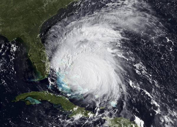
Handout image courtesy of NOAA shows a visible view of Hurricane Irene captured by the GOES-East satellite on August 25, 2011. The National Hurricane Center is still predicting Irene to reach category 4 status within the next day. Hurricane and tropical storm watches are in effect for much of the Carolina coastline. [Photo/Agencies] |
BUXTON - A monstrous Hurricane Irene tightened its aim on the Eastern Seaboard on Thursday, threatening 65 million people along a shore-hugging path from North Carolina to New England. One of the nation's top experts called it his "nightmare" scenario.
The Category 3 storm with winds of 115 mph - the threshold for a major hurricane - would be the strongest to strike the East Coast in seven years, and people were already getting out of the way.
Tens of thousands fled North Carolina beach towns, farmers pulled up their crops, and the Navy ordered ships to sea so they could endure the punishing wind and waves in open water.
All eyes were on Irene's projected path, which showed it bringing misery to every city along the I-95 corridor, including Washington, New York and Boston. The former chief of the National Hurricane Center called it one of his three worst possible situations.
"One of my greatest nightmares was having a major hurricane go up the whole Northeast Coast," Max Mayfield, the center's retired director, told The Associated Press.
He said the damage will probably climb into billions of dollars: "This is going to have an impact on the United States economy."
The head of the Federal Emergency Management Agency said damages could exceed most previous storms because so many people live along the East Coast and property values are high.
"We've got a lot more people that are potentially in the path of this storm," FEMA Director Craig Fugate said in an interview with The Associated Press. "This is one of the largest populations that will be impacted by one storm at one time."
The storm would "have a lot of impact well away from the coastline," he added. "A little bit of damage over big areas with large populations can add up fast."
Irene was massive, with tropical-force winds extending almost twice as far as normal, about the same size as Katrina, which devastated New Orleans in 2005.
"It's not going to be a Katrina, but it's serious," said MIT meteorology professor Kerry Emanuel. "People have to take it seriously."
 |
|
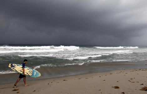
Connor Murray takes advantage of the heavy surf near the Ocean Crest Pier in Oak Island, North Carolina, prior to the arrival of Hurricane Irene August 25, 2011. [Photo/Agencies] |
The governors of North Carolina, Virginia, Maryland, Delaware, New York and New Jersey declared emergencies to free up resources, and authorities all the way to New England urged residents in low-lying areas to gather supplies and learn the way to a safe location.
Irene was expected to come ashore Saturday in North Carolina with 115 mph winds and a storm surge of 5 to 10 feet. It could dump a foot of rain, with as much as 15 inches falling in some places along the coast and around Chesapeake Bay.
With heavy rain and storm surge predicted for the nation's capital, organizers postponed Sunday's dedication of the Martin Luther King Jr. Memorial on the National Mall.
Already in South Florida near West Palm Beach, authorities blame the rough ocean churned up by the outer bands of Irene caused eight people to be injured when a wave knocked them off a jetty. Also, a man swimming off Jupiter was swept away by a large wave, but later ended up ashore.
Scientists predict Irene will then chug up the coast. Some forecasts showed it taking dead aim at New York City, with its eye passing over Brooklyn and Manhattan before weakening and trudging through New England.
If the storm strikes New York, it will probably be a Category 1 or 2, depending on its exact track, hurricane specialist John Cangialosi said.
Hurricanes are rare in the Northeast because the region's cooler seas tend to weaken storms as they approach, and they have to take a narrow track to strike New York without first hitting other parts of the coast and weakening there.
Still, strong storms have been known to unleash serious damage in an urban environment already surrounded by water.
On Thursday, Ocean City, Md., officials ordered thousands of residents and tourists to abandon the beach community. Earlier in North Carolina, three coastal counties issued evacuation orders covering more than 200,000 people, including tourists and full-time residents. President Barack Obama declared an emergency for the state, allowing for federal help.
Farmers grimly accepted the fate of their crops. Strong winds and widespread flooding could mean billions of dollars in losses for corn, cotton, soybean, tobacco and timber growers. While most farmers have disaster insurance, policies often pay only about 70 percent of actual losses.
In Virginia, officials recalled Hurricane Isabel in 2003, which came ashore as a Category 1, killed more than 30 people and caused more than $1 billion in property damage. The low-lying Hampton Roads region is at high risk of flooding from storm surge and heavy rains. Widespread power outages are likely.
The Navy ordered many of its ships at Norfolk Naval Station out to sea to wait out the storm, including the aircraft carrier USS Dwight Eisenhower, as well as destroyers and submarines.
Gearing up for approaching hurricanes is an almost annual occurrence in coastal North Carolina and Virginia, so planning is extensive and almost second-nature.
Building codes along the Outer Banks require structures to be reinforced to withstand sustained winds of up to 110 mph and gusts up to 130 mph. Houses close to the water must be elevated on pilings to keep them above storm surges, and required setbacks preserve sand dunes to provide additional protection.
It could be a different story as the storm moves up the coast.
In Washington, where residents were rattled by a rare earthquake Tuesday, officials warned people to be prepared for stormy conditions regardless of Irene's exact path and to stay away from the beaches in the region.
The Philadelphia area could get more than a half-foot of rain, accompanied by sustained winds up to 50 mph. Mayor Michael Nutter said it could be the worst storm in at least 50 years. August has already been one of the rainiest months in city history.
New Jersey Gov. Chris Christie asked all visitors to the shore to get out by midday Friday. He said Irene was poised to be a "serious, significant event," with flooding a threat across the entire state. A mandatory evacuation was ordered for Cape May County.
In a normal hurricane, tropical storm-force winds extend about 150 miles from the eye. Irene's winds extend nearly 250 miles.
Another worry is that the ground is already saturated in the Northeast after a wet spring and summer. That means trees and power lines will be more vulnerable to winds, like during Hurricane Isabel, Mayfield said.
New York is especially susceptible with its large subway network and the waterways around the city, Mayfield said.
"In many ways, a Category 2 or stronger storm hitting New York is a lot of people's nightmare," said Susan Cutter, director of the Hazards and Vulnerability Research Institute at the University of South Carolina.
High water in the harbor and rivers, along with a high tide at the end of the month because of the new moon, could cause serious flooding. New York's three airports are close to the water, putting them at risk, too, Cutter said.
And if the storm shifts further to the west, placing New York City on the stronger right-hand quadrant of the storm, "that is what's going to push this wall of water into the bays and the Hudson River."
Related Stories
Hurricane Irene batters small islands of Bahamas 2011-08-26 08:03
US capital braces for Hurricane Irene 2011-08-26 07:12
Hurricane Irene displaces over 11,657 people 2011-08-24 11:51


Hot Topics
The European Central Bank (ECB) held a conference call late on Sunday ahead of the market opening, pledging the ECB will step in to buy eurozone bonds with efforts to forestall the euro zone's debt crisis from spreading.
Editor's Picks

|

|

|
|

|

|