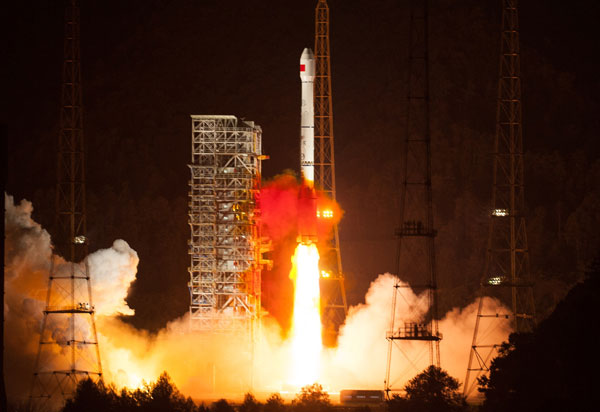
China successfully launches a Beidou navigation satellite into space on Oct 25, 2012. [Photo/Xinhua]
Two nations to build joint facility for Beidou navigation technology
China's homegrown Beidou Navigation Satellite System will begin overseas operations next year in Thailand.
The move is the first step in efforts to promote Beidou abroad, with the initial phase expected to focus on the Association of Southeast Asian Nations.
Officials with the Wuhan Information Technology Outsourcing Service and Research Center and Thailand's Geo-informatics and Space Technology Development Agency made the announcement in Bangkok on Wednesday.
An agreement with an expected value of $319 million inked by the countries in March established a commitment to cooperate on construction of Thailand's geospatial system, giving the country access to China's advanced technology, products and services.
The two sides have agreed to start building a model satellite station based on Beidou in an industrial estate in Thailand's eastern Chon Buri province next month, and nationwide construction will begin early next year.
Anond Snidvongs, executive director of the Geo-informatics and Space Technology Development Agency under Thailand's Ministry of Science and Technology, said the Thai government will list the construction of a disaster forecasting system based on Beidou into its overall economic development plan.
Beidou will be used in many sectors, such as agricultural disaster warning, transportation, power distribution and environment, he said.
Thailand is one of the 10 members of ASEAN to whom promoting Beidou "is of great strategic significance to China", according to Jin Xiaoming, director of international cooperation for the Ministry of Science and Technology.
"It can prove Beidou is capable of providing cross-boundary navigation services," he said prior to Wednesday's announcement. "Moreover, this means the rest of the world will rank China as an equal in navigation services."
There are four major navigation systems: Beidou, the United States' Global Positioning System, Galileo in Europe and Russia's Glonass.
GPS was put into service in 1964 and its satellite network covers the globe, while Glonass had full global coverage by 2011 and Galileo is still under construction.
"Beidou will be able to provide a global service by 2015," said Liu Junyi, deputy director of the Wuhan center.
Beidou went into service in 2011 with a 16-satellite network over the Asia-Pacific region.
In September, during the 10th China-ASEAN Expo in the Guangxi Zhuang autonomous region, Premier Li Keqiang signed a series of agreements with heads of ASEAN countries, which included satellite remote sensing cooperation.
Also at the expo, Science and Technology Minister Wan Gang signed a framework agreement for satellite applications with Indonesia's Ministry of Science and Technology.
Zhao Gang, deputy director of the International Science and Technology Cooperation Program of New and Renewable Energy, said President Xi Jinping's visit to Indonesia in early October also promoted steady development of friendly cooperative relations.
ASEAN is the first step for Beidou to develop markets in the Asian-Pacific region, he said.
"Most of Beidou's satellites are near the equator, which contributes to relatively good geographical conditions for ASEAN to receive strong signals," Ran Chengqi, spokesman for the China Satellite Navigation Office, told reporters earlier.
Jin Xiaoming at the Ministry of Science and Technology said Beidou provides services in agriculture, atmospheric analysis, education, medical services and mineral exploration.
"Beidou has gradually formed a complete service system, and we are now initiating the civil communication service in ASEAN," he said.
The Ministry of Science and Technology is helping Chinese navigation companies carry out a market survey in Brunei, and signed a memorandum to promote navigation services in Laos.
The ministry also started personnel training in ASEAN. The Indonesian government allocates special funds to the cooperation project, according to Jin.
"I'm optimistic about Beidou's long-term prospects," Jin said. "ASEAN members do have a strong need for satellite remote sensing, and the cooperation has just begun."
Grace Lyu, chairwoman of Beidou Communication, a China-US venture engaged in providing navigation services to ASEAN countries, views the market as very promising.
The company is trying to lower the cost of the system, which will help the system to fully enter the international market.
"In 2020, there will be more than 100 satellites in the sky, of which 35 belong to China. In the future of satellite navigation, Beidou will play a very important role," she said.
Contact the writers at jijin@chinadaily.com.cn and cheng-yingqi@chinadaily.com.cn
Xinhua News Agency contributed to this story.
Copyright 1995 - . All rights reserved. The content (including but not limited to text, photo, multimedia information, etc) published in this site belongs to China Daily Information Co (CDIC). Without written authorization from CDIC, such content shall not be republished or used in any form. Note: Browsers with 1024*768 or higher resolution are suggested for this site.
License for publishing multimedia online 0108263 Registration Number: 20100000002731 ![]()