Strongest sandstorm of year hits Beijing


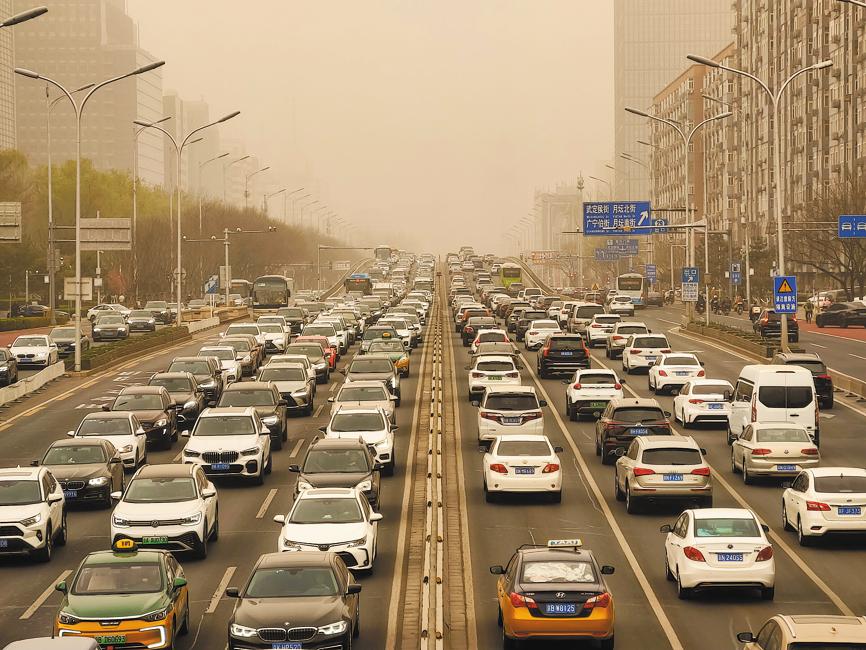
A sandstorm that originated in Mongolia on Tuesday swept through vast swaths of northern China, including Beijing and Tianjin, causing heavy pollution, reducing visibility substantially and disrupting public transportation.
The storm, which according to the National Meteorological Center was the strongest in China so far this year, affected several provincial-level regions. Satellite images showed that by Wednesday morning, it had covered 854,000 square kilometers, roughly twice the size of the US state of California.
The affected areas included the Inner Mongolia autonomous region and Hebei, Gansu, Shaanxi, Liaoning, Jilin and Heilongjiang provinces, besides Beijing and Tianjin municipalities. Visibility remained lower than 1,000 meters in some parts of northern China as the NMC issued a yellow alert, the lowest in the three-tier weather warning system.
The level of PM10 — inhalable particles with diameters of 10 micrometers or less — increased rapidly and reached a peak concentration of 1,667 micrograms per cubic meter around 6 am on Wednesday, according to the Beijing Ecological and Environmental Monitoring Center.
On days when air quality is good, the PM10 level usually remains below 150 micrograms per cubic meter.
The Beijing Center for Disease Prevention and Control issued an advisory on its official WeChat account, urging people with chronic respiratory illnesses to avoid outdoor activities and recommended that commuters wear brightly colored clothes to avoid road accidents amid poor visibility.
The capital's parks suspended operations of boats and cable cars to ensure the safety of visitors.
The sandstorm will move southeast and weaken, starting from dusk on Wednesday, the NMC said, adding that the air quality in Beijing is expected to return to "a good level" after that.
Hohhot, the capital of the Inner Mongolia autonomous region, maintained an orange alert, the second-highest level in the weather warning system.
Zhang Tao, chief forecaster at the NMC, said that strong winds blowing over loose sand and soil particles create the conditions for sand and dust storms.
Higher temperatures in spring loosen the top soil, particularly in arid and semi-arid regions. Strong winds blowing over deserts in Mongolia, western Inner Mongolia and Gansu, carry the particles up, Zhang explained.
Since the beginning of March, China has experienced four rounds of "dusty weather", which is more than normal, the NMC's chief forecaster said. It is hard to say whether there will be more such weather conditions this spring, but the center will keep close watch in April and May, he added.
Last spring, northern China had eight rounds of dusty weather. From 2000 to 2021, there were 10.7 rounds of dusty weather on average, according to the 2022 China Climate Bulletin.
From 1981 to 2010, Beijing had an annual average of 2.4 days of dust and sandstorms in March. The capital's longest sandstorm of this century lasted for nine days.


- Xi's enduring bond with Xizang mirrors region's dramatic transformation
- Foreign influencers arrive to turn focus on culture, creativity
- V-Day parade to unveil advanced weapons
- Xi: Build a united, prosperous new Xizang
- Doctor by day, UFC fighter by night
- Tsinghua University welcomes over 4,000 new undergraduates