WORLD> America

|
WORLD> America
|
|
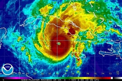
Paloma becomes Category 4 storm, heads toward Cuba
(Agencies)
Updated: 2008-11-08 21:31 GEORGE TOWN– Paloma became an "extremely dangerous" Category 4 hurricane early Saturday, dumping wind and rain on the Cayman Islands and threatening to strike hurricane-ravaged Cuba as a major storm, forecasters said.
The late-season storm had top sustained winds of near 140 mph (225 kph) and was expected to bring total rainfall accumulations of 5 to 10 inches over the Cayman Islands as well as central and eastern Cuba. The new forecast from the National Hurricane Center in Miami called for Paloma to make landfall in Cuba as a major hurricane late Saturday or early Sunday with maximum-sustained winds of at least 111 mph (178 kph). Cuba already is suffering from Hurricanes Ike and Gustav, which struck the island earlier this season and together caused an estimated $9.4 billion in damage. "It's not like it's new to them, unfortunately," said Dave Roberts, a US Navy hurricane specialist. Cuban official newspaper Granma, recalling past late-season hurricanes such as a 1932 storm that killed about 3,000 people, said Paloma poses "a potential danger for the island." At 7 a.m. EST, the center of Paloma was just southeast of Cayman Brac and moving toward the northeast near 8 mph (11 kph). The storm's center was expected to move away from Little Cayman and Cayman Brac on Saturday morning and was about 165 miles (265 kilometers) southwest of Camaguey, Cuba. The Cayman Islands government asked all hotels to remove guests from the ground and first floors. Nearly 40 people were already staying in the islands' seven shelters. Water service across Grand Cayman was turned off, and power would likely be cut as the storm neared, hazard management director Barbara Carby said. |