WORLD> America

|
WORLD> America
|
|
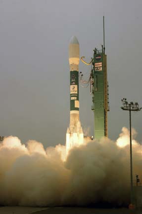
US launches new high-resolution Earth-imaging satellite
(Xinhua)
Updated: 2008-09-07 08:59 WASHINGTON -- GeoEye-1, the world's highest-resolution commercial Earth-imaging satellite, was launched into space from Vandenberg Air Force Base in California, the satellite maker GeoEye Inc. announced Saturday.
"Based upon the data we saw, the satellite is performing properly and ready to begin the next phase towards meeting its mission requirements," Bill Schuster, GeoEye chief operating officer, said in a statement after the launch. GeoEye-1 will now undergo a calibration and check-out period before imagery products will be available for sale. GeoEye-1 will simultaneously collect 0.41-meter ground resolution black-and-white (panchromatic) images and 1.65-meter color (multispectral) images. Designed to take digital images of the Earth from 681 km and moving at a speed of about seven km per second, the satellite camera can distinguish objects on the Earth's surface as small as 0.41-meter in size. "Later this fall, we will start providing high-resolution color imagery of the Earth from our newest satellite to customers around the globe," said GeoEye's CEO Matthew O'Connell. GeoEye-2 is slated for launch in 2011, according to O'Connell. |