WORLD> America

|
WORLD> America
|
|
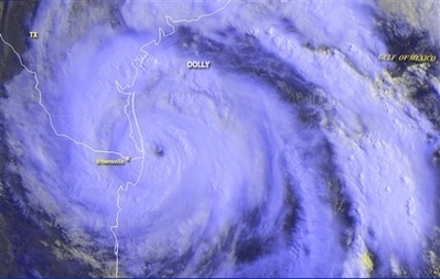
Dolly lashes Texas coast as Category 2 hurricane
(Agencies)
Updated: 2008-07-24 00:18 MIAMI - Forecasters at the National Hurricane Center in Miami say Hurricane Dolly has strengthened to a Category 2 storm with maximum sustained winds near 100 mph.
The storm center is about 30 miles east-northeast of Brownsville, Texas. The eye will cross the coast near the Texas/Mexico border in a few hours. People should stay inside during the relative calm of the eye because winds will soon increase quite rapidly. Dolly strengthened as its leading edge lashed the Gulf Coast near the Texas-Mexico border with heavy rain and powerful winds. The center of the Category 1 hurricane was expected to make landfall later Wednesday and dump up to 15 inches of rain, threatening flooding that could breach levees in the heavily populated Rio Grande valley. At 9 a.m. EDT Wednesday, the storm's center was about 40 miles east of Brownsville, moving northwest at about 8 mph. A hurricane warning was in effect for the coast of Texas from Brownsville to Corpus Christi and in Mexico from Rio San Fernando northward. Utility company AEP Texas reported power outages to more than 9,200 customers in Cameron County. The causeway linking South Padre Island to the mainland remained closed early Wednesday. Dan Quandt, a spokesman for the town's emergency operations, said winds were picking up to around 50 mph and were expected to increase later Wednesday morning. He said there was a steady rain falling, but no reports of flooding. A sign on a hotel blew off, but no one was injured and it did not pose a hazard, he said. National Weather Service radar indicated a tornado 18 miles northeast of the Harlingen Valley Airport on Wednesday morning. A tornado watch was in effect for several counties in the area until 10 a.m. CDT Wednesday. Cities and counties in the Rio Grande valley were preparing Tuesday night as officials feared heavy rains could cause massive flooding and levee breaks. Texas officials urged residents to move away from the Rio Grande levees because if Dolly continues to follow the same path as 1967's Hurricane Beulah, "the levees are not going to hold that much water," said Cameron County Emergency Management Coordinator Johnny Cavazos. There was intermittent light rain late Tuesday in Brownsville, and Cavazos said he expected outer bands to move over the area overnight. Charles Hoskins, deputy emergency management officer for Cameron County, said there were nearly 2,000 people in six shelters in the county. In Hidalgo County, a little bit farther inland, six shelters holding about 900 people were open, said Cari Lambrecht, a county spokeswoman. She said people living in low-lying areas were encouraged to come to shelters. "It's so much easier for them to go now instead of us having to pull them out later," she said. Late Tuesday, the causeway linking the mainland to South Padre Island was closed as winds ramped up, Quandt said. He said no one would be allowed onto or off of the island, with the causeway not likely to open again until Wednesday evening at the earliest. He said winds were not predicted to reach speeds requiring evacuation. In Mexico, Tamaulipas Gov. Eugenio Hernandez said officials planned to evacuate 23,000 people to government shelters in Matamoros, Soto La Marina and San Fernando. People began trickling in Tuesday night to five shelters set up throughout the border city of Matamoros. City officials said three other shelters were ready in case they were needed. Forecasters predicted Dolly would dump up to 15 inches of rain and bring coastal storm surge flooding of 4 to 6 feet above normal high tide levels. Forecasters said Dolly's eye should hit the coast around midday Wednesday. |