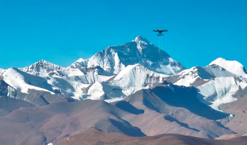
Tech rescue
As climate risks, climbing dangers rise, drones save lives on Mount Qomolangma


Editor's note: In this weekly feature China Daily gives voice to Asia and its people. The stories presented come mainly from the Asia News Network(ANN), of which China Daily is among its 20 leading titles.
In March, a chilling incident unfolded in the frigid heights of Qomolangma, also known as Mount Everest in the West. Three Chinese trekkers — a father and his two daughters — lost their way in the Dingboche area. With only two porters and no guide, they had pushed on to Cho La pass, a treacherous trail perched 5,420 meters above sea level. By nightfall, the trekkers were missing, and their disappearance sparked panic in the region.
At 10 pm, their hotel launched a desperate search-and-rescue mission. Six guides were dispatched to scour the area, but after three grueling hours in the harsh mountain terrain, they found nothing. Fear gripped the hotel area, where the Chinese were residing.
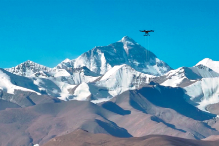
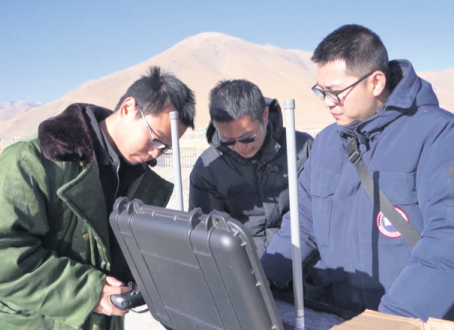
Then a stroke of technological luck intervened. Airlift Technology, a local drone-mapping startup, had team members staying in a nearby hotel. Without hesitation, they deployed a drone borrowed from a foreigner. Within an hour it had located the stranded trekkers. The rescue team moved swiftly. Lives were saved — not by chance, but by the eyes in the sky.
According to Airlift Technology, this was just a glimpse of what drones can do in Nepal's high mountains. If equipped with thermal detection, drones can pinpoint the location of missing climbers — if they are still alive.
With 3D mapping capabilities, drones can remotely scan the icy landscapes of places like the Khumbu Icefall, measuring the length and depth of crevasses. Climbers and guides can assess the mountain's dangers and be warned of potential avalanches or collapsing ice slabs.
That warning came just in time for one expedition in April.
Months ago, while preparing the route on Mount Pumori — standing at 7,161 meters, just 8 kilometers from Qomolangma — Airlift's drone spotted a hanging serac, a huge block of unstable ice. The expedition was called off. Climbers and guides escaped death that day.
Such interventions, however, cannot always prevent tragedy.
On April 7, around noon, a massive avalanche thundered above Camp II(5,600 meters) of Annapurna, the world's 10th highest mountain. A team of sherpas from Seven Summit Treks were carrying bottled oxygen for their clients' summit push. The avalanche caught Ngima Tashi and Rima Rinje. Another sherpa, Pemba Thenduk, was swept along but miraculously survived.
Despite days of relentless searching, there was no trace of Ngima and Rima.
On April 11, Seven Summit Treks wrote in a heartbreaking Facebook post, "It is no longer possible for anyone to survive this long under the mass of snow and ice. Prolonging search efforts would risk more lives. With a heavy heart, we have decided to suspend the search and bid farewell."
"If drones can be used to deliver oxygen and supplies, we can reduce the number of risky trips sherpas must undertake," said Milan Pandey, cofounder of Airlift Technology.
The sherpas — Nepal's high-altitude trailblazers — have long been the silent heroes of Himalayan expeditions. They guide climbers, ferry supplies, and prepare routes, often putting their lives on the line. The dangers they face are relentless.
Three sherpas were killed by an avalanche in the Khumbu Icefall alone last year.
This treacherous stretch — an ever-shifting river of ice just below Everest Base Camp — is so dangerous that most climbers attempt it only between 3 am and 5 am, when the ice is most stable. As the sun rises, melting ice becomes unstable, and avalanches are frequent.
On April 18, 2014, a falling serac buried 16 sherpa guides in the icefall, ending that year's climbing season. The Himalayan Database records 48 deaths on the Icefall between 1953 and 2024.
Now, the mountain may finally have a new kind of helper.
"After our successful operations on Everest, we're piloting drones on Annapurna this September," said Pandey."We flew drones up to 6,500 meters this spring, carrying over 30 kilograms of supplies in -25 C and winds of 45 kilometers per hour."
Where sherpas take 6 to 7 hours to climb carrying 12 kg of gear, drones do the same in 10 minutes.
This spring alone, Airlift mobilized two heavy-lifter drones that transported 2.5 metric tons of supplies — including 300 kg of garbage — in and out of the Khumbu Icefall.
The drone reached a record 6,130 meters, the highest documented drone delivery.
This spring, almost all the ladders and ropes used to prepare Qomolangma's route were flown by drones up to Camp I.
The Icefall Doctors, a group of specialist sherpas mobilized by the Sagarmatha Pollution Control Committee, or SPCC, usually carry over 20 ladders and hundreds of kg of ropes by hand. This year, drones lifted 444 kg of such equipment.
"It was super fast," Pandey said. "This year, the drones supplied 900 kg of equipment for the 8K Expeditions up to Camp I. They also delivered 150 oxygen cylinders for Asian Trekking, six at a time — each weighing four liters."
The DJI drone weighs 96 kg and has a payload capacity of 32 kg.
The results were impressive.
For instance, when the Icefall Doctors discovered a crevasse longer than expected, they needed extra ladders. Instead of climbing down to Base Camp and back — a day's delay and a risky journey — a drone delivered four ladders in just two minutes. The sherpas finished the section within an hour.
Traditionally, sherpas travel from Base Camp to Camp I and back in 10 hours, including 6 hours of climbing. With drones, the task now takes 10 minutes, including loading.
Weather challenges
There were still challenges. In one instance, a drone was forced into an emergency landing when winds hit 66 kmph. "Drones can fail," Pandey admitted, "but people won't die. We're planning a full-fledged drone operation next spring."
They don't come cheap though, but much more cost-effective and safer than helicopters. The price of a DJI drone is $70,000 with taxes.
Pemba Sherpa, executive director of 8K Expeditions, the company entrusted to prepare routes from Camp II to the Qomolangma summit this spring, said, "There is no doubt that drones are a lifesaving initiative. The human risk is zero.
"When sherpas don't have to carry loads, their performance improves.
"Besides, though the commercial aspect of the drone is yet to be properly assessed, preliminary reports suggest it is over 10 times cheaper to transport goods through drones than through choppers," he said.
Operators say the average travel time for rope-fixing sherpas from Base Camp to Camp I was cut by 90 minutes this year.
Could drones one day bring supplies down to Lukla, Qomolangma's gateway airport?
"Technically, yes," Pandey said. "But our focus is on emergency support and garbage removal. We don't want to displace porters' jobs."
That's a valid concern. Hundreds of locals depend on Qomolangma for income. Porters form the backbone of Nepal's trekking industry.
The SPCC collected more than 83 tons of garbage from Qomolangma this spring alone. That included 25,056 kg of paper, plastic, and clothing; 8,374 kg of metal and glass; 17,861 kg of kitchen waste; and a staggering 31,797 kg of human waste. Also retrieved: 788 used gas canisters and 1,802 spent batteries.
The mountains are magnificent — but they are unforgiving.
Technology may never fully tame them. But this spring, Nepal took a small yet bold step toward a safer future in the death zone, where once only courage treaded — and now, drones fly.
The Kathmandu Post, Nepal