Distinct development belts and an integrated transport network are at the
core of a plan for co-ordinated regional development of Beijing, Tianjin and
Hebei.
Wu Liangyong, an academician of the Chinese Academy of Engineering and
professor at Tsinghua University, put forward the proposals at a press
conference to release the plan over the weekend.
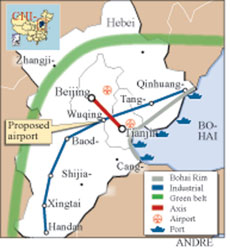
The region will consist of four development links, divided geographically
into "one axis and three belts."
The axis is the line linking Beijing and Tianjin that sustains the core
functions of technology research and development.
The three belts are:
The mountain belt that runs through the cities in the Yanshan Mountains and
Taihangshan Mountain areas in the region;
The traditional industry belt that threads through cities which are home to
traditional industries such as steel; and
The Bohai Rim that includes ports, cities and the Binhai New Area development
zone.
The proposals for the three belts are:
For the mountain belt in the north of Hebei Province, building an ecological
corridor that circles Beijing and Tianjin and provides the two municipalities
with environmental protection and ensure the region's balanced development.
For the industry belt, a restructuring of traditional industries in cities
including Shijiazhuang and Baoding, both in Hebei, and supplying energy to other
development zones.
For the Bohai Rim, greater co-ordination between ports and protection of the
maritime environment.
In addition to the axis and belts, Wu also suggested small economic hubs be
formed around counties to develop small- and medium-sized enterprises.
Wu and his colleagues also proposed that the region upgrade its
transportation system by developing an integrated network.
For instance, Wu said the long-awaited second international airport for the
capital should be based in the Beijing-Tianjin corridor, which is the core of
economic development in the region with a dense population and a robust economy.
Taiziwu Village in Tianjin's Wuqing County is an ideal location, he said.
Wu also proposed that Beijing's planned seventh ring road be extended into
Hebei, and pass through Zhuozhou, Gu'an and Langfang cities in the province and
Beijing's Pinggu District.
The towns on the seventh ring could become new development destinations and
ease the pressure on existing centres by attracting investment.
The plan by Wu, a renowned expert in urban planning and architecture, is
expected to serve as reference for government decision-making with several
ministries already collaborating on regional planning for the
Beijing-Tianjin-Hebei zone.
Wu's plan has won the backing of regional economic researchers, who, however,
warned that the proof of the pudding lies in implementation.
Chen Liangwen, a researcher at the Chinese Regional Economics Research Centre
affiliated to Peking University, said Wu's plan might help clearly define the
role of different cities in the region as they are now all integrated into their
own development zones.
"With clear orientation, the cities can avoid repetitive construction, find
their competitive edge and facilitate each other's development," Chen told China
Daily.
Weaving all the cities, counties and towns into one economic framework will
help to change the region's current status of "a rich core surrounded by poor
neighbours," he added.
But Chen warned that smooth implementation of any co-ordinated regional
development needs the combined efforts of all local governments.
In a major step in that direction, Beijing and Hebei earlier this month
signed a milestone co-operation agreement on, among other things, water
resources and energy supply.
Other experts said they welcome systematic planning for the region, which has
been lagging behind other economic entities such as the Pearl and Yangtze river
deltas in co-ordinated development.