Young farmers cotton on to high-tech help


Farmers need to pay attention to all the factors that can affect the growth of cotton — temperature, moisture, rainfall, wind, air pressure and sunshine. They also need to be cautious about the weeds, pests and germination rate.
In traditional fields, farmers will go and check a particular plot when necessary. As early as January or February, they will start contacting long-term workers, asking them to help manage the cotton fields during the whole process, with free accommodation on offer to them.
A cotton filed as large as 200 hectares will need 20 to 30 long-term workers. They need to walk around the field every day to inspect the growth of the cotton plants, spot diseases and pests, making decisions about weeding and use of pesticides.
Now a drone can finish inspecting the whole field within a day.
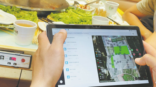
When the Super Cotton Farm project was launched at the beginning of 2021, the duo first built a digital agricultural platform that employs the Beidou Navigation Satellite System, installing soil sensors in the field, meteorological stations, and cameras to form an agricultural internet of things.
Throughout the 140 days of the entire life cycle of cotton, the IoT would keep monitoring the plants and collecting images of the field and data about the weather and soil conditions.
In early spring, with high-precision navigation and autonomous driving technology, farm machines equipped with autopilot devices plowed and leveled the land automatically.
When it was time to sow, the IoT would send data about temperature and soil moisture to the smartphones of Ai and Ling, who would decide the sowing date. Later, they sent unmanned tractors to complete the task efficiently and precisely.
Then, remote-sensing drones rendered high-definition digital maps of the cotton field that facilitated unmanned aerial and ground vehicles to spray pesticides and fertilize the land.