Highest warning issued as Typhoon Fitow nears
Updated: 2013-10-06 07:03
By Xinhua and China Daily(China Daily)
|
|||||||
China's meteorological authority on Saturday issued a red alert, the highest in its weather warning system, as Typhoon Fitow approached the country's southeast coastal areas.
At 5 am Beijing time, the center of Fitow, the 23rd typhoon to hit China this year, was 680 kilometers east of Taipei, the National Meteorological Center said in a statement.
The center said the typhoon is expected to move northwestward at a speed of about 15 km per hour, during which it could continue to strengthen slightly.
Fitow is likely to make landfall in the coastal areas between central Zhejiang province and northern Fujian province between Sunday night and Monday morning, according to the center.
|
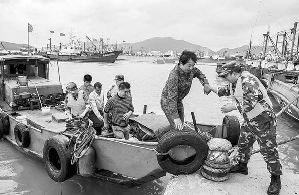
Border patrol officers help fishermen take shelter from Typhoon Fitow at a port in Zhoushan, Zhejiang province, on Saturday. The National Meteorological Center issued a red alert as the typhoon approached China's southeast coastal areas. Xu Yu / Xinhua |
It is unusual for a typhoon to make landfall in southeast China in October and urged local authorities and residents to be alert and keep abreast of all relevant information about the storm.
Fitow is expected to bring strong gales to the waters around northeastern and northern Taiwan, as well as eastern areas of the provinces of Zhejiang and Fujian during Sunday.
From Sunday, Fitow is forecast to bring heavy rain to southeastern China, while eastern and southern areas of Zhejiang province are likely to be hit by heavy rainstorms, according to the center.
Also on Saturday, China's maritime authorities issued an orange alert warning of high waves.
China has a four-tier, color-coded weather warning system, with red representing the most severe situation, followed by orange, yellow and blue.
Fitow was expected to reach the southeastern part of the East China Sea on Saturday afternoon or night, according to the National Marine Environmental Forecasting Center.
The typhoon will bring waves as high as 12 meters in the south of the East China Sea and the waters around the Diaoyu Islands until midday on Sunday, with waves of up to five meters in the north of the East China Sea and in the Taiwan Straits.
The center also warned of severe storm tides, with water levels expected to rise by as much as 90 centimeters in the coastal areas of Zhejiang and Fujian from Saturday night to Sunday noon.
The center urged shipping to be cautious. It also advised coastal authorities to take precautionary measures, undertake regular patrols and make sure dikes and fishery facilities are secure.
The National Commission for Disaster Reduction also issued an early disaster warning on Saturday, asking local governments to be prepared to minimize losses.
Civil affairs bureaus in the affected areas have been asked to remain on duty around the clock, increase monitoring, issue early warnings, evacuate tourists in threatened areas and help fishing boats back into port.
The commission asked local authorities to carry out emergency plans and allocate relief materials and funds when necessary to ensure daily necessities are provided for those affected by the typhoon.
The tourism administration of Ningbo, Zhejiang province, ordered that tourist attractions should be closed by 5 pm on Saturday.
Thirty people were killed and one is still missing after Usagi, the most powerful typhoon this year, made landfall in Guangdong province on Sept 22.
(China Daily 10/06/2013 page2)