Anew dimension in the space war
Updated: 2016-06-01 06:50
By Wang Yuke(HK Edition)
|
|||||||
As Hong Kong struggles with land shortage, the need for precision planning grows. A team of local researchers believes it has come up with a solution to all the conflicts. Wang Yuke reports.
What will the future look like? We can get a peek with three-dimensional (3D) mapping software that can foretell the impacts changes will have on any given environment. It can foretell effects on prevailing winds on the amount of sunlight, predict effects on the populated regions brought about by any emergency and natural disaster, and even make sense of the outcomes for Chinese white dolphins' habitat in light of Hong Kong's third runway development.
It can predict which hospitals are most likely to be cut off from access in a flood. It adds up to an invaluable aid to urban planners and property developers - possibly even to provide solutions to the endless wrangles over new developments in our cheek-by-jowl city, starved for affordable housing.
The Novel Integrated 3D Mapping Mode, developed by a team of scientists at the Hong Kong Polytechnic University (PolyU), was acclaimed with a Gold Award at the 44th International Exhibition of Inventions in Geneva in April.
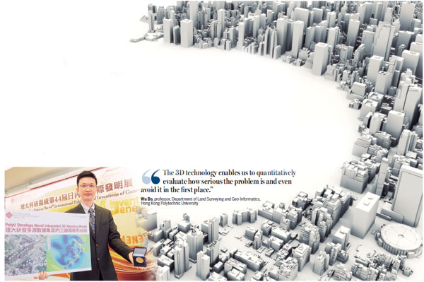
The key, says Professor Wu Bo who headed the team at PolyU's Department of Land Surveying and Geo-Informatics, is precision measurement.
In the case of a crowded city like Hong Kong, where buildings practically tumble over one another, he cites examples of the many rows arising between developers and nearby residents. People see their comfortable living arrangements torn apart by new developments that can impede sunlight, spoil the view, block the air flow, and generate nightmarish traffic.
Wu thinks that many disputes can be resolved in advance, if developers and urban planners use the 3D mapping and modeling system.
The precision is obtained by combining aerial imagery, which produces accurate horizontal models, with laser imagery which gives more precise measurements of vertical planes.
The system allows greater accuracy and predictability over a wide range of environmental considerations.
Property developers and urban planners can solve a lot of potential problems by examining proposed buildings to ensure proper ventilation, pleasing sightlines, efficient distribution of sunlight, and smooth ingress and egress of traffic flow, said Wu.
He noted a case in a Sha Tin neighborhood. Proprietors in nearby buildings complained a newly built high-rise complex blocked the breezes and interfered with TV signals. Wu said his team measured wind velocity, 1.5 meters above ground. The team combined 3D mapping and modeling, rendering a ventilation simulation measured in tens of meters. They created a color coded map, showing how the winds affected each floor of every nearby building. The study revealed that some buildings at higher elevations received no breeze, leaving them poorly ventilated and stuffy. Lower levels were virtually blasted by wind velocities measuring between 4.675 m/s and 5.95 m/s.
"The 3D technology enables us to quantitatively evaluate how serious the problem is and even avoid it in the first place," remarked Wu.
The technologies always have been applied separately, so that over the past 15 years, a large body of aerial images and laser scans has been accumulated. These have produced significant variances of measurement in data from identical locations, Wu declared.
"If the 3D system is made accessible to the general public, people will be able to take a virtual tour of any apartment they fancy. Before settling payment, they can get a sense of the ventilation, natural lighting, heat distribution, outdoor noise and scenic views," said Wu.
Informed of any defects of potential problems that exist in the apartment, buyers have a chance to weigh their choices. They might eventually give it up, due to inadequate sunlight, traffic noise, poor ventilation or an unappealing view.
Even flawed apartments, said Wu, can be modified, by adding more light to compensate for insufficient sunlight. Better heating can be installed if the 3D model reveals the rooms are poorly insulated. This can be determined by examining the window to faade ratio.
Wu said his team experimented with 3D mapping and modeling system on a new office building at PolyU, to measure noise levels on different floors. Team members measured the noise level on the ground, followed by simulating the noise level at certain floors by using 3D modeling. Then noise distribution for the whole building was mapped out. The modeling results largely validated actual experience.
Wide applicability
To generate an informative and accurate 3D model requires sophisticated 3D modeling techniques. Some 3D modeling systems are reasonably accurate but fail to capture the qualitative character of a city, while some systems can replicate geometric structures but cannot deliver hard facts required for analysis, design or legal rigor, said David Jonas, a project manager of AAM, a spatial information technology provider specializing in 3D modeling of urban areas. He supervised a project involving 3D modeling a site between Wan Chai and Central in 2011 and another project all over the city using a laser system.
Jonas says the applicability of 3D mapping and modeling is not confined to town planning. It can be used for emergency planning so as to minimize fatalities and property damage in a disaster. It can speed up emergency response, with detailed flood modeling. It is able to identify the best locations for schools and medical facilities, based on demographics; show the way when it comes to energy supply and transport planning. It can even help to manage taxation policy, electric solar panel optimization and public consultation.
City planners can ask questions such as "show me all the buildings with more than 10 school-age children who live more than 3 km from a school", or "how many buildings are taller than prescribed town planning regulations", or "how many office units are over 500 square meters, within 1 km walk of a MTR station", or "show me which hospitals will be cut off by flood waters with a storm surge of 3 m in height", or "how many people would need to be evacuated within 500 m of building XYZ, and which roads would be most heavily traveled in this exodus."
Storing data as individual models, by isolating and mapping every single building of an area, allows people to ask questions like "where will the shadow of a planned 80-story building at Tsim Sha Tsui fall at dusk on June 24?" said Jonas. Similarly, when advertising hoardings are loaded as separate models, the model can accurately display what is visible and what is obscured. People could set their own criteria when searching for an apartment, such as "100 square meter in size, at least five stories up, within 200 m of a MTR station and 500 m of a school". Not only can the user easily locate matching properties, but they also can click on an apartment to glimpse the view that they would see from the window if they really move in.
Wu says his team is continuing to work on its system, to remove flaws and achieve full automation that will facilitate more efficient processing. Most of today's modeling work still has to be done manually. "We want our model to be the first to achieve fully automatic input of parameters," Wu said in confidence.
Full realization of the benefits of 3D mapping and modeling will take time, because the technology is still all but unknown to most people, said Wu. "It is difficult to achieve widespread popularity among ordinary people, but the technology is available to stakeholders, like housing agencies and property developers." If estate agents are able to gather housing information using interactive 3D simulation software, they can offer their clients more concrete advice.
Smart city
The technology can also help the city to achieve the goal of becoming a "smart city".
The smart city is meant to capitalize information processing and communication technologies to enhance systems, operations and services.
The concept was put forward by IBM in 2008 and quickly caught on with governments. Hong Kong put the "smart city" high on its list of priorities, highlighted the concept in the 2015 and 2016 policy addresses.
Even though Hong Kong is a front runner in 3D technology development, the city is a late comer in 3D technology adopted for planning purposes. Wu complained that the government continues to rely on 2D mapping and modeling for city planning.
He reasoned that Hong Kong has a long history of urban planning using the time consuming, obsolete 2D approach. Now, it's about time for the city to embrace high-end 3D technology. "We can hardly estimate the exact year when our city can fully embrace the 3D alternative, but 2D mapping and modeling is an impediment to the development of a truly smart city," Wu asserts.
Urban Hong Kong is an extremely complex environment, where space is a scarce resource, Jonas stressed, and detailed 3D planning is needed to assure the space is used wisely and in a sustainable way.
"Everyone needs to find smarter ways of doing things. City planning emphasizes the analysis of the current situation and assessing the impact of proposed changes in the urban layout. The analysis can be done in 2D, but if there is anywhere in the world where the third dimension is vital, it is Hong Kong," Jonas concludes.
Contact the writer at
jenny@chinadailyhk.com
|
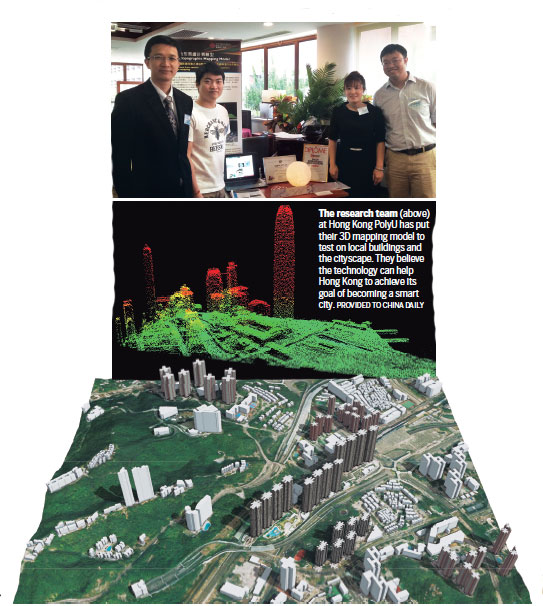
The research team (above) at Hong Kong PolyU has put their 3D mapping model to test on local buildings and the cityscape. They believe the technology can help Hong Kong to achieve its goal of becoming a smart city. Provided to China Daily |
(HK Edition 06/01/2016 page7)