 |
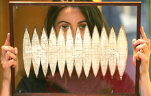
| A 500-year-old world map, seen
here being held by a Christie's employee in April 2005, that was
the first to name a newfound continent west of Europe
'America,' was sold for one million dollars at an auction in London (AFP)
| |
A 500-year-old world map that was the first to
name a newfound continent west of Europe "America" was sold for one
million dollars at an auction in London.
Charles Frodshan, a London book and manuscript dealer, bought the map
for 545,600 pounds during bidding at Christie's.
Christies said the map was also the first printed portrayal of the Earth as a globe,
the first that distinguishes North and South America individually, and the
first depiction of a Pacific
Ocean, it said.
Printed in 1507 by the German geographer Martin Waldseemuller, the map
is just one of four in existence and had been expected to fetch between
500,000 and 800,000 pounds.
The document, which is the centrepiece of a sale of maps,
atlases and globes by Christie's, was discovered in February 2003 after a
European collector realised that it was one of the maps in his collection.
"This is one of the most exciting discoveries of my career, and
represents the pinnacle in the
history of map making," said Tom Lamb, director of the auction house's
book and manuscript department, in a statement.
"This simple sheet of paper holds so many new and anticipated
discoveries, all created with an enormous leap of faith by a venerable
geographer in a small town in Lorraine (eastern France)," he said.
Most history documents credit the Genoa-born explorer, Christopher
Columbus, with being the first European to discover the so-called New
World of North and South America in 1492, but he was convinced it was part
of Asia.
A second Italian, Amerigo Vespucci, actually argued that the landmass
to the west of Europe was a whole new continent.
Until the map's publication, the layout of the world had been based on
the knowledge of the ancient Greeks. But in 1505, Rene II, the Duke of
Lorraine ordered a group of scholars led by Waldseemuller to draft a new
world map.
He gave them a French translation of Vespucci's travels and as a
result, the scholars decided to name the new landmass "America" after the
traveller's first name.
The first example of Waldseemuller's original map was discovered in
1871 and is kept at the University of Minnesota in the United States. The
other two are in Germany.
A fifth, much larger version, printed eight years later, was purchased
by the Library of Congress in Washington for 10 million dollars
in 2003.
(Agencies) |
一张具有500年历史的世界地图在伦敦拍卖,最后成交价格高达100万美元。这张地图首次标出了欧洲以西的新大陆并将其命名为“美洲”。
在克里斯蒂拍卖行的竞价过程中,伦敦书稿经销商查尔斯·福特森最终以545,600英镑的价格购得这张地图。
克里斯蒂拍卖行表示,这也是世界上第一张将地球绘制成球形的印刷地图,它首次将美洲大陆分为南北两个部分,而且还第一次描绘了太平洋。
这张地图于1507年由德国地理学者马丁·瓦尔德塞米勒印制,是至今仅存的类似的四张地图中的一张,原预估价为50万至80万英镑。
直到2003年2月,欧洲一位收藏家在其藏品中发现了它,这张地图才得以重见天日。它也是克里斯蒂拍卖行所经手的地图、地图集及地球仪中的精品。
克里斯蒂拍卖行图书及手稿部门的负责人汤姆·拉姆在声明中称,“这是我从业以来最让人激动的发现,它缔造了地图绘制历史上的颠峰。”
“在这薄薄的一张纸中,蕴含着许多具有预知性的新发现,人类对世界的认识由此出现一次重大飞跃,这些都出自洛林(法国东部)小镇的一位德高望重的地理学者。”
据大量历史文献记载,出生于热那亚的探险家克里斯托弗·哥伦布在1492年成为第一个发现所谓“美洲新世界”的欧洲人,不过哥伦布深信,那是亚洲的一部分。
另外一位意大利人亚美利哥·维斯普西则认为,欧洲西侧的这大片陆地是一块全新的大陆。
在这张地图出版之前,人们对世界的认识一直建立在古希腊文明的基础之上。但在1505年,洛林公爵雷内二世下令让以瓦尔德塞米勒为首的一批学者绘制新的世界地图。
他交给学者们一本法文版的维斯普奇游记,结果,学者们决定根据作者的名字(Amerigo)给新大陆命名为“America(美洲)”。
根据瓦尔德塞米勒的原版地图印制的第一张地图于1871年被发现,目前保存在美国明尼苏达大学。另外两张则保存在德国。
八年后印制的版面较大的“第五张地图”由美国国会图书馆于2003年以1000万美元购得。
(中国日报网站译) |