First group of Gaofen pictures are clearest ever


Sharp, high-resolution satellite images show Chinese characters on buildings
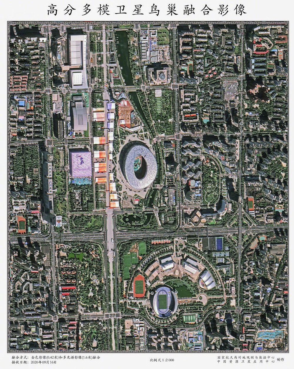
The first batch of pictures taken by China's best optical Earth-observation satellite for civil use was published on Tuesday, becoming the clearest photos ever created by a Chinese civilian satellite.
More than 20 sub-meter-resolution images taken by the High-Resolution Multi-Mode Imaging Satellite, the latest in China's Gaofen high-resolution Earth-observation satellite fleet, were made public by the China National Space Administration at a ceremony in Beijing, depicting places in the capital, Gansu province's Lanzhou and Jiayuguan, and the Gezhouba Dam on the Yangtze River.
These images are so clear that viewers can identify subtle details such as high-voltage power lines between two transmission towers and Chinese-language characters on top of buildings.
Developed and built by the China Academy of Space Technology, the satellite carries high-resolution cameras, an atmospheric synchronization corrector as well as an experimental device to verify the laser communication terminal mounted on the spacecraft.
It was launched by a Long March 4B carrier rocket from the Taiyuan Satellite Launch Center in Shanxi province in July.
Currently, the satellite is making an in-orbit trial run. Once it starts formal service, it will be mainly used to obtain high-resolution remote-sensing data for several industries like natural resources surveys, emergency management, agricultural and rural area administration, environmental protection, and forestry and grassland monitoring, the space administration said.
Designers said the spacecraft's high-resolution capability will make work that now requires a lot of manpower and resources easier. For instance, it will enable agricultural researchers to examine growth conditions of different crops in the same farmland and help mineral companies detect and identify metal mines without needing to send in personnel.
It can take high-resolution pictures through heavy smog thanks to its atmospheric synchronization corrector, designers added.
China launched the Gaofen program in May 2010 and listed it as one of 16 important national projects in science and technology.
The program aims to form a space-based, high-resolution Earth observation network.
So far, 20 Gaofen satellites have been launched, and all are in active service.
Images and data from the Gaofen satellites have been widely used in more than 20 industries across China and have helped reduce the country's dependence on foreign remote-sensing products.
Tong Xudong, chief designer of the Gaofen program, said more than 80 percent of satellite images that China needed to buy from foreign countries have been replaced by Gaofen products.
China has also launched a website to give users around the world access to images and data of the Earth generated by Gaofen satellites.


- Pandas headed for Madrid in sign of bilateral friendship
- Niche tourism sector gains healthy advantage in shanghai
- Climate change blamed for heavy rain in the south
- Xi urges effort to build world-class military medical universities
- Ten photos from across China: April 19 - 25
- Shenzhou XVIII astronauts enter space station