Team tackles 'historic' challenge, remeasures world's highest peak


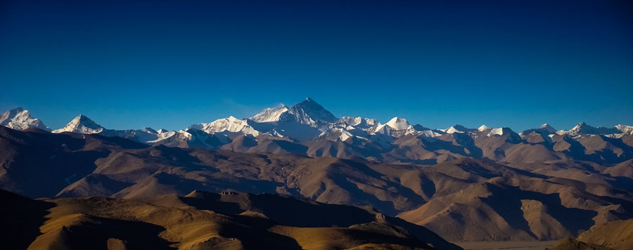
Most seasoned mountain climbers aspire to scale Qomolangma (known in the West as Mount Everest), spurred by the thrill of reaching the world's highest peak.
But for Khim Lal Gautam, Nepal's chief surveyor and leader of the first Nepali government-appointed team to measure Qomolangma, climbing the mountain is a source of pride.
Gautam's team went on a monthlong expedition in April to remeasure the height of Qomolangma, which is more than 8,000 meters above sea level. This was meant to settle the debate in the international science community on whether the mountain shrank after a magnitude 7.8 earthquake devastated Nepal in April 2015.
Gautam welcomed the Department of Survey's decision to entrust him with a "historic, important and challenging job".
Qomolangma "is the highest peak in the world, so (its altitude) is a concern of the whole world as well", he said.
Gautam's team has sent the data they collected to the Department of Survey for processing. The results are expected to be out by next year.
The team's attempt to measure Qomolangma this time was particularly challenging. Gautam said the spring season was not particularly good for climbing, since there was only a very short period of clear weather. The team also had to stay at the summit for more than an hour, since they had to set up their equipment and gather data.
Gautam said staying at the summit for a long time is not advisable, and most mountaineers prefer to descend as soon as possible.
Many mountain climbers suffer from lack of oxygen, or hypoxia, if they stay on the summit too long.
Gautam said the team also had to work at night so they would not be disturbed by other mountain climbers. This posed an additional problem, since it was colder at night and the surveyors had to wear fleece gloves and large mittens while installing the equipment.
Gautam said one surveyor struggled with hypoxia while descending the summit but survived thanks to the team's climbing guide, who managed to borrow a bottle of oxygen from another guide.
"The whole mission was a bundle of challenges. Fortunately, we could manage them all," he said.
After Gautam's team scaled the mountain, they used satellite navigation system receivers to collect data that was then transmitted to colleagues at the ground station.
Mahar Lagmay, a professor at the National Institute of Geological Sciences of the University of the Philippines, told China Daily that the 2015 earthquake would definitely have changed Qomolangma's altitude because the tremor forced the underlying tectonic plates to collide.
Qomolangma is in the Himalayan range, which was formed millions of years ago after the Indo-Australian plate collided with the Eurasian plate. The collision pushed the Earth's crust up and formed mountains. These tectonic plates continue to move, and geologists estimated that Qomolangma is growing by a few inches each year.
However, that conventional knowledge was challenged after the 2015 earthquake.
In April 2015, four days after Nepal's deadly earthquake, data from Europe's Sentinel 1A satellite showed that a broad swath of ground near Kathmandu, the Nepali capital, had been lifted vertically by about 1 meter, according to a report by online news site Live Science.
UNAVCO, a geoscience research consortium based in Colorado in the United States, interpreted these radar images and estimated that Qomolangma's height had dropped by about 2.5 centimeters because the Earth's crust had relaxed after the earthquake released pent-up strain.
In June 2015, China's National Administration of Surveying, Mapping and Geoinformation said the earthquake had moved Qomolangma 3 centimeters to the southwest.
In an earlier interview with China Daily, Xu Xiwei, who was then deputy head of the Institute of Geology at the China Earthquake Administration, said that "the scale of such movement is normal and won't affect life in the area".
Kul Bahadur Gurung, the general secretary of the Nepal Mountaineering Association, said the association lobbied for the Nepali government to remeasure Qomolangma to clear the confusion.
Gurung said mountaineers need to be updated on the latest developments in Qomolangma's measurements, since this will affect the logistics of mountain climbing.
For Kaiz Galang, a Filipina mountaineer who trekked to the Qomolangma base camp in 2014, it is important to know the exact measurement of any mountain to ensure safety.
"Climbing Mount Everest needs careful planning and meticulous preparation. Everything must be properly calculated," she said.
Galang said any change in Qomolangma's altitude will also entail an adjustment in a mountaineer's budget, provisions and oxygen supply.
Nepal started its project to measure the peak in December 2017, when the Department of Survey conducted a consultation workshop on the methods to be used in remeasuring Qomolangma.
In 2018, a technical team from the department went to the eastern Nepali district of Solukhumbu to do precise leveling work, according to a report by Xinhua News Agency.
Qomolangma, which straddles China and Nepal, has attracted some of the world's most adventurous trekkers.